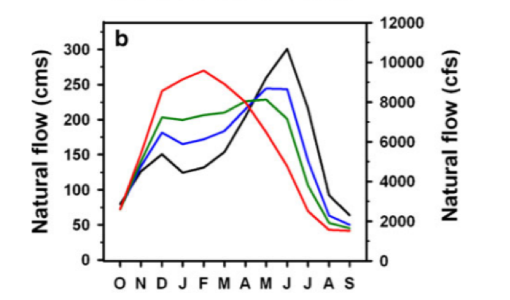
 Predicted waterflow of Yakima river, October to September. Black = historic average, Blue = 2020 – 2040, Red = 2080. Source: Vano et al., “Climate Change Impacts on Water Management and Irrigated Agriculture in the Yakima River Basin, Washington, USA.” Climatic Change 102, No. 1 (2010): 287–317. https://doi.org/10.1007/s10584-010-9856-z. Climate changes and the local environment: For Yakima county located in central Washington, the effects of climate change include both higher temperatures and an increased risk of drought. Yakima is in a Mediterranean climate similar to the climate of Greece and California. This climate is characterized by mild winters and hot summers; most precipitation – an average of 8.3 inches in Yakima – falls in the winter instead of the summer. Already hot, Yakima is expected to get hotter. Analysis by NOAA suggests that even in a “low emission” scenario, the weighted-average daily maximum temperature will be 61.4 degrees Fahrenheit in 2080. With “high emissions,” this temperature will increase to 64.5 degrees Fahrenheit. There is a large difference between these temperatures and the 2000’s maximum daily temperature of 55.3 degrees Fahrenheit. Drought is more likely to occur because of climate change. A tributary of the Columbia River, the Yakima river starts in the Cascade mountains. Water from the Yakima river comes from five reservoirs run by the U.S. Bureau of Reclamation: Lake Keechelus, Lake Kachess, Lake Cle Elum, Rimrock Lake, and Bumping Lake. The total volume of these reservoirs is around one million acre-feet of water. Because of winter snowpack, these reservoirs can easily fill-up in the spring. Snowpack is essential for these reservoirs to remain full. Less snowpack, however, would result in lower water levels in the reservoirs which are more likely to remain empty as the dry summer months continue each year. 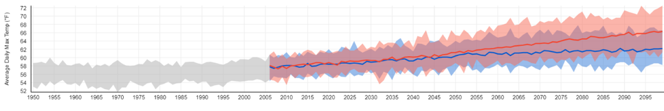 Average daily maximum temperatures predicted for Yakima county, 1950-2099: Grey - historically observed data to 2006 and similar conditions to 2099, Blue – lower emissions scenerio, Red – high emissions scenerio. Source: NOAA Climate Explorer. How we know: Data for rainfall was projected using a “variable infiltration capacity macroscale hydrology” model. One of the advantages of this simulation type is that scientists can use it to predict changes based not only on watersheds in Washington but based on other watersheds, that are out of the state, that could impact Washington’s water. This data was generated between 1916 and 2006, however it has been modified on each month to better reflect the changing climate that will occur 2020s, 2040s, 2080s via the delta method. Using the data from these simulations, scientists can evaluate both snowpack and streamflow. The “Snow Water Equivalent” graph below compares the predicted amount of water in a snowpack on April first in comparison to historical data. Additionally, projected and historical temperature data is supplemented from the National Oceanic and Atmospheric Administration (NOAA) climate explorer tool (National Oceanic and Atmospheric Administration 2020). This free, reliable, online tool gathers precipitation from on the ground metrological stations located both around the country and around the state. This tool predicts both scenarios with high greenhouse emissions, and low greenhouse emissions. 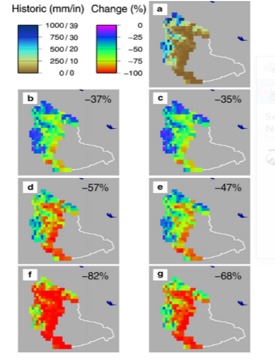 Predicted changed in Snow Water Equivalent in Yakima April 1st. a= Historical data, b&c= 2020s, d&e=2040s, f&g=2080s, A1B and B1 SRES models. Source: Elsner et al. Human consequences: Because Yakima gets so much sun, it is a center for agriculture with the highest market value from farming in the state. In addition to growing the most squash in the state, the county grows the most apples, cherries and pears. Furthermore, Yakima county produces more hops than any where else in the United States. In 2017, there were 2,952 farms in Yakima, with a combined total area of 1,781,463 acres. Ninety-six percent of these farms are family owned. The Yakima river basin is one of the most irrigated areas in the United States. Fifteen percent of farm area, or 260,023 acres, are irrigated through canals, many of which were built in the late nineteenth century. Yet, since 1977, the Yakima basin has experienced seven droughts, and numerous low water years. Climate change will only exacerbate these issues, droughts will become more frequent and more severe. As most of the precipitation shifts from snowpack to rain, there will be less water stored in reservoirs. Therefore, the Yakima river will have less streamflow. For farmers who get their water from the Yakima river, a drastically reduced flow will hamper growing efforts. In addition, the Yakima river provides crucial spawning and rearing habitat for several salmon species. Fish, of course, need water to survive. One study found that the spawning ground for Coho Salmon and Fall Chinook will decrease because of climate change. The Yakima Tribe of Indians has tribal water rights to protect fish in the Yakima river under an 1855 treaty, however these rights were vague. The famous Ecology v Acquavella et. al. case settled in 2019 established primary water rights for the Yakima nation and addressed instream flows necessary to maintain fish and other aquatic life. Further reading:Ecology v Acquavella - Washington State Department of Ecology. Yakima River Basin. USGS. Identifying Stakeholder-Relevant Climate Change Impacts: A Case Study in the Yakima River Basin. Climatic Change. Climate change impacts on water management and irrigated agriculture in the Yakima River Basin, Washington, USA. Climatic Change. Article author: Devlin Mee, William O. Douglas Honors College, Central Washington University
Article editor: Dr. Tamara Caulkins, William O. Douglas Honors College, Central Washington University
2 Comments
 Average maximum temperature in Chelan county from 1950 to 2006 with maximum temperature predictions up to 2099. Source: The Climate Explorer, National Environmental Modeling and Analysis Center (NEMAC), University of North Carolina, Asheville. Climate Changes and the Local Environment:Ever since the early 2000s, Chelan County in Washington has experienced an increase in average maximum temperature. This trend in increased heat is predicted to reach well into the future. At the same time, the average precipitation shows signs of decreasing, with the average precipitation from 2000-2020 being .26” less than in the twenty years previous. In addition, snow cover over the last five decades, been disappearing earlier and earlier in the year across areas of Russia, Alaska, Canada, and in parts of the northwestern United States. These factors have all contributed to an increase in wildfires across Washington, with a significant increase in large wildfires in the state starting in 2012. In 2012 alone, there were 12 large wildfires in Washington, four of them affecting Chelan County. At that point in time, Chelan county boasted the eighth highest occurrences of wildfires based on data spanning from 2003 to 2012. Then, in 2015, the fires grew to such a size that Washington state had to declare a state of emergency. That year, Chelan county was rocked by fire that burned 88,985 acres surrounding the city of Chelan. This fire was attributed to drought conditions cause by minimal snowpack and unusually high temperatures. Increased temperatures, decreased precipitation, and shorter snow cover seasons are elements of climate change that have huge negative impacts on the health of forests, leading to larger and more devastating wildfires. Though wildfires are a natural element of new growth in forested areas, the increase in devastation and frequency of large-scale fires is a danger to both humans and the natural environment. The ecosystem of Washington state forests could be severely impacted by the increase in large-scale wildfires. 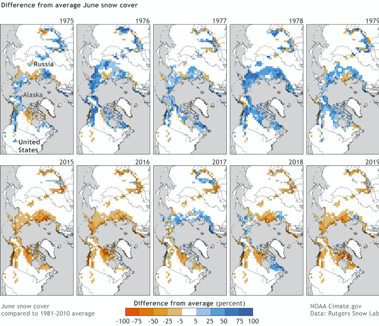 Snow cover decrease in the Northern Hemisphere from 1975 to 2019. Source: Global Climate Dashboard, National Oceanic and Atmospheric Administration (NOAA) Climate.gov, based on maps from Rutgers Snow Lab. How We Know: Much of the data used in this project comes from the following interactive tools: The Climate Explorer, the Global Climate Dashboard, and Climate at a Glance. Graphs from the Climate Explorer that show the increase in Chelan County’s average maximum temperature were created by combining observed historical data and current measurements to predict and model possible future trends in temperature. Climate at a Glance and The Climate Explorer are both run by the National Oceanic and Atmospheric Administration. County specific data is collected from NOAA’s US Climate Divisional Database, which contains climate data spanning from 1895 to 2020. Snow cover data has been collected from satellite images that have been mapping the snow extent of the Northern Hemisphere since the 1960s. This data, now collected daily as opposed to weekly as was the case in the sixties, is corroborated by various other measuring tools including observations, precipitation gauges, and weather stations with pressure-sensitive measuring tools. The fire data used in this report has been compiled from various sources including a Washington State Wildland Fire Profile from 2013, a report on the Chelan Complex fire of 2015, and various articles. 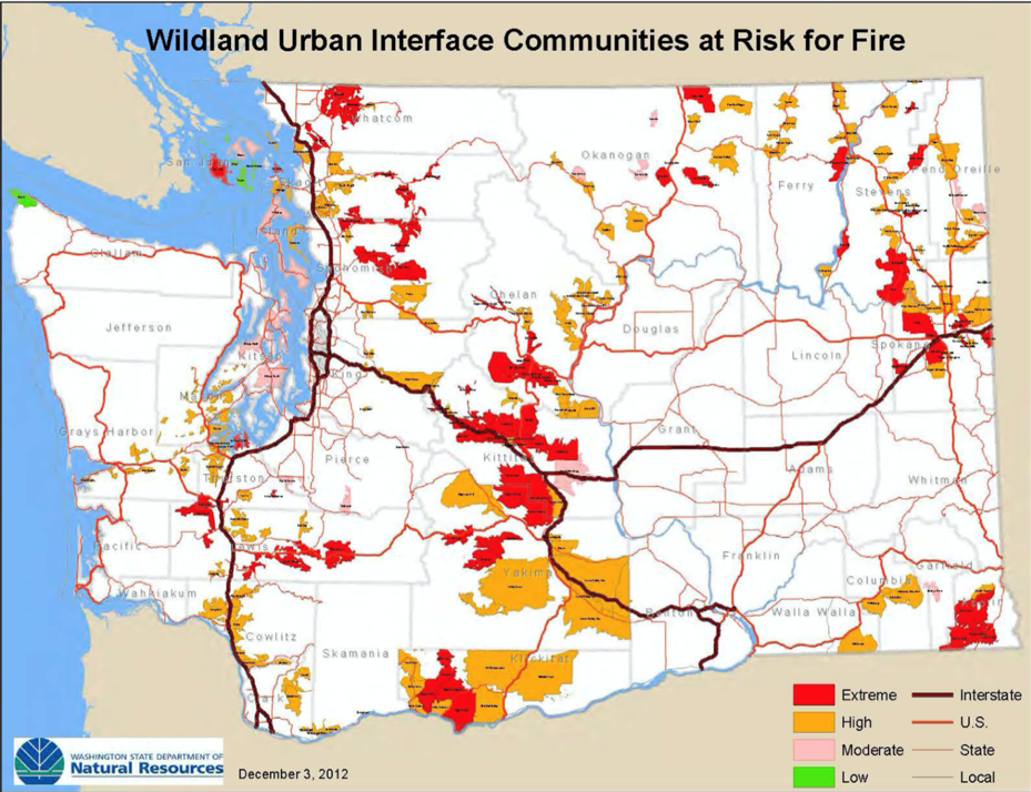 Urban areas with adjacent areas of wildfire fuel in Washington State as of 2012. Source: Washington State Hazard Mitigation Plan, map from the Washington State Department of Natural Resources. Human Consequences:The increase in wildfires in Chelan county poses a threat for residents and their surroundings. The Chelan Complex fire alone destroyed 58 buildings, causing $23,513,366.00 worth of damage. Economically, dealing with fires is very expensive. Between 2010 and 2016, Washington spent nearly a half a billion dollars fighting fires and maintaining fire departments. This imposes significant economic strain on all residents of Washington. Not only can people be affected by the economic repercussions of increasing wildfires, the rising threat means increased health risks as well. Though only a few wildfire deaths have been recorded in Chelan county, wildfire smoke increases the risk of respiratory and cardiovascular health issues. Smoke inhalation can also aggravate preexisting health conditions such as asthma and angina. People over the age of 65, children and infants, pregnant mothers, and people with lung, respiratory, and heart problems are all particularly susceptible to adverse effects. Though steps such as burn bans are being implemented in attempts to decrease the rate of wildfires in Chelan county, the decreasing precipitation and snow cover combined with the increasing heat means that forests are more at risk than ever, and forests at risk means that people are at risk. Further reading: Washington Forest Protection Association Rutgers University Global Snow Lab Climate Time Machine Earth Observatory Temperature, Precipitation, and Drought Article author: Gracie Camp, William O. Douglas Honors College, Central Washington University
Article editor: Dr. Tamara Caulkins, William O. Douglas Honors College, Central Washington University 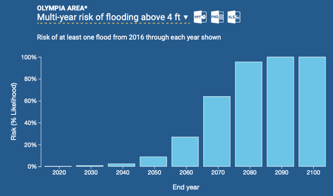 Sea level projections in Thurston County from 2016 to 2100. Source: 2012 report of the U.S. National Research Council. Climate changes and the local environment: A 2016 Climate Central study revealed that human actions are resulting in rising global sea levels. As a result, some primary concerns are how populations, buildings, infrastructure, land and contamination risks will be affected by these rising sea levels. For Thurston County, there is an increased risk of flooding, especially in the most vulnerable areas that closely line large bodies of water. Thurston County, home to the city of Olympia, rests on the bank of the Puget Sound inlet. A U.S. National Research Council report projected a 9% risk of at least one flood over 4ft occurring sometime between today and 2050 in the Olympia area. By the year 2060, this percentage is projected to rise to 24% before drastically increasing to 62% by the year 2070 with flood levels expected to rise well above 4ft. The frequency and intensity of heavy rain events is also projected to increase according to a 2015 study conducted as part of the Climate Impacts Group’s “State of Knowledge” series that focused on the Puget Sound area. Increased precipitation is directly linked to increasing global air temperatures that will lead to more freshwater inflows into the Puget Sound, particularly during winter months. Additionally, rising air temperatures would increase the likelihood of harmful algal blooms in the ecosystem. While Washington state as a whole is at risk to the effects of climate change, areas such as Thurston county that are near central bodies of water are particularly vulnerable. Rising temperatures and sea levels will directly impact the Puget Sound and its surrounding areas. The effects of climate change will surely have a range of sociological, ecological and economic impacts on Thurston county. 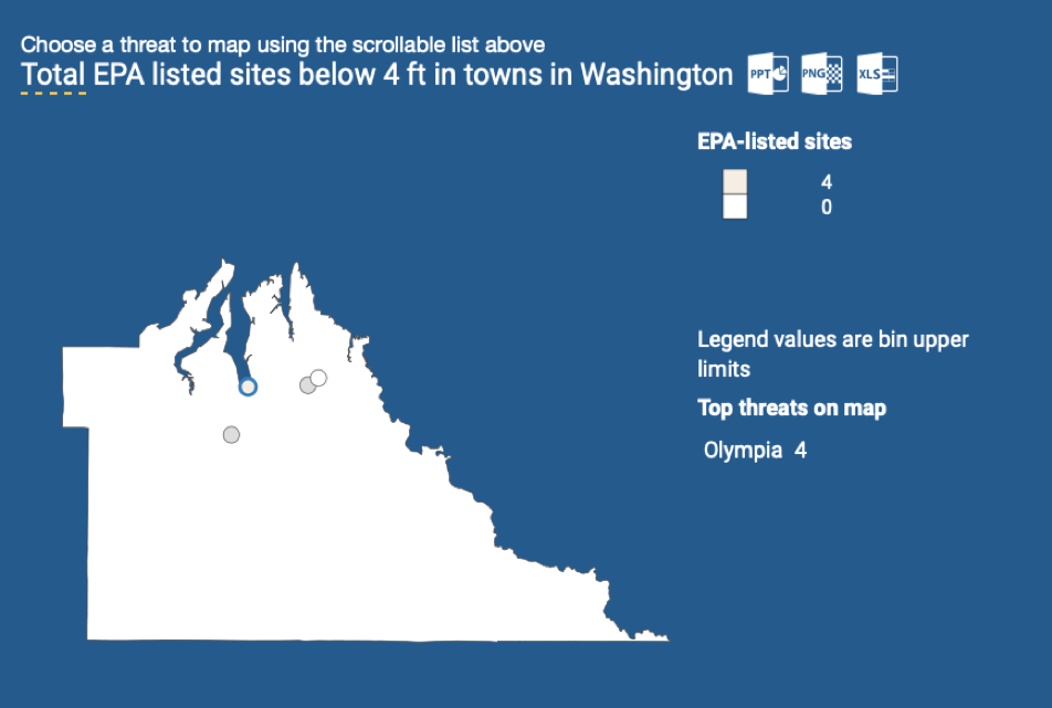 Areas susceptible to flooding and contamination risk from various threats including EPA sites, RADINFO sites, hazardous waste sites, sewage plants. Source: EPA. How we know: These projections rely primarily on two tools that are freely accessible online: the “State of Knowledge Report - Climate Change in Puget Sound” and the Surging Seas, Risk Finder Website. The “State of Knowledge” series summarizes research on the probable effects of climate change on the water, lands and people of the Puget Sound. The synthesized work was created by the Climate Impacts Group, which aims to increase understanding and awareness of climate change through sharing information and conducting scientific studies. Data, projections and relevant research were all used to compile this report. The Surging Seas tool aims to provide accessible, science-based, localized information to help people better understand and respond to the climate crisis as it specifically relates to rising sea levels. The National Oceanic and Atmospheric Association (NOAA) provides Surging Seas with accurate coastal elevation and tide station data. More scientific data was pulled from 2012 U.S. National Research Council records while population-specific data was obtained through the 2010 U.S. Census. 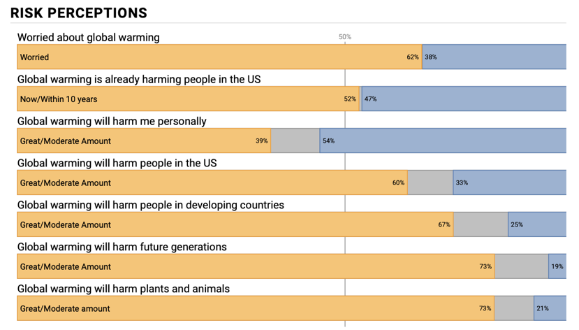 Public opinion and risk perception of adults in Thurston county on global warming in 2016. Source: Yale Climate Opinion Maps. Human Consequences: Flooding and rising sea levels disproportionately harm vulnerable populations like the elderly, children, and people experiencing homelessness. The Thurston county homeless census found that 800 individuals were homeless or lived in emergency or transitional housing in 2019. While this is a slight decrease since the year prior, it is still a significantly large number. Many of these homeless individuals are unsheltered and positioned to be hit the hardest in the case of flooding or any other major climate events. In addition to vulnerable communities being at risk from elevating sea levels, the effects of climate change will impact other areas as well. Agriculture lies along many rivers, infrastructure is vulnerable, homeowners and their property are at risk, and clean water sources may be contaminated. Climate change has the capacity to influence change in many areas and, eventually, everyone will be considered vulnerable regardless of their socioeconomic status. When surveyed in 2016, residents of Thurston county had a higher than average awareness of climate issues, yet a lower than average concern for the personal toll that global warming will have on them. Further Reading: Article author: Kiersten Kimminau, William O. Douglas Honors College, Central Washington University
Article editor: Dr. Tamara Caulkins, William O. Douglas Honors College, Central Washington University 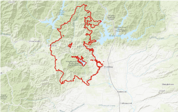 Regions burned in the 2018 Carr Fire in Shasta County. Source: CAL Fire Climate changes and the local environment: Shasta County in northern California is one of multiple areas in the state that has experienced the drastic social and physical effects of wildfires. In 2018 alone, there were millions of acres nationwide burned by wildfires and over 1 million of those acres were in California alone. Over 38,000 people were evacuated from the city of Redding, the Shasta county seat. Also in 2018, the town of Paradise just south of Shasta county in Butte county was almost completely destroyed. Climate change is a major factor in the prevalence of wildfires. Concurrent with the rise in average temperatures since the year 2000, eight out of the 10 biggest fires on record in California, have occurred. The state’s fire season is also longer, increasing from 65 days a year in the 1970s to 140 days in the 2000s. Some people may confuse wildfires with controlled fires that occur in many places across the nation. Controlled fires benefit the environment by allowing for new growth, killing diseases affecting local wildlife, and clearing the forest floor, among many other positive outcomes. Wildfires, in contrast, are unpredictable and often detrimental. In addition to destroying homes and animal habitats, wildfires have been known to release black carbon and greenhouse gases that have an adverse effect on air quality. 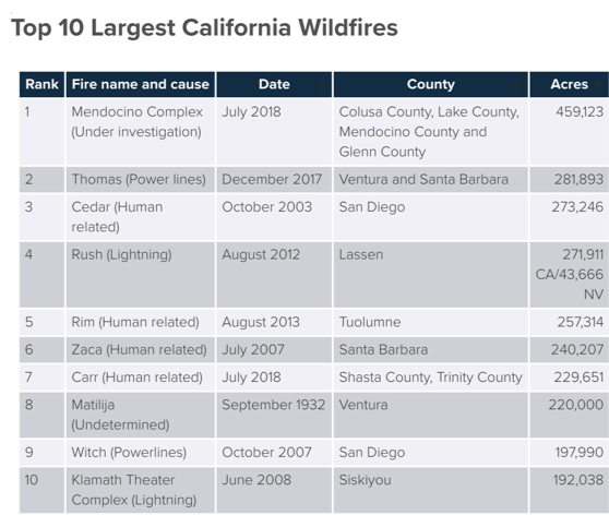 The Carr fire in Shasta and Trinity counties burned 220,651 acres, making it the seventh most destructive wildfire in California 2000. Source: Insurance Information Institute. How We Know: Across the state of California, the prevalence of wildfires has become rampant, especially in Shasta County. Although there are many local factors such the location of the fires, wind conditions, or form of ignition that can determine the effects of wildfires, there is a strong correlation between larger warming effects in the Western U.S. and acres burned with about 40% of the cause being attributed to warming among other factors, according to Carbon Brief. The same research also suggests a major connection between the increase in seasonal temperatures and the extent of fires since the 1980s. The increase in acreage burned by wildfires is consistent with global rising temperatures as a result of climate change.  Traumatic events experienced by children and adolescents during local wildfires. Source: Canadian Journal of Psychiatry. Human Consequences: There are many effects that residents of Shasta County have experienced as a result of the increase in wildfires. As noted by the Shasta County Department of Resource Management, one of the more common results of wildfires is increased smoke exposure; this can be a major issue, especially for sensitive populations such as children, whose lungs are still in the process of development. In addition, children can be even more at-risk for detrimental effects of wildfires due to the extreme trauma that occurs during evacuations and witnessing the fires. Being displaced from home, watching communities burn, and evacuation stress are all causes of extreme emotional trauma for wildfire victims. Although children are not the only at-risk population affected by these disasters, they do require more care and attention than the average adult during an emergency. One area that especially affects older children is excessive exposure to media coverage. News coverage, while important for informing and educating people during emergencies, can cause anxiety, misunderstandings, and difficulties recovering emotionally for children with easy access to media sites. According to The National Child Traumatic Stress Network, exposure to both the natural disaster itself and the coverage post-incident can be detrimental to the wellbeing of children and families. Wildfires also can have a dramatic impact on local economies. Shasta County relies on tourism-related businesses surrounding Shasta Lake, Shasta Caverns, and the Shasta-Trinity National Forest. According to an article from Scientific American, the constant wave of fires throughout the summer season caused a 50% decrease in local rentals as well as less foot traffic at local shops. When the physical environment is almost unbearable for local residents, there is bound to be less tourism throughout the usual seasons. While it may seem that wildfires only cause physical destruction, there are also many human consequences that arise after a traumatic disaster. Further Reading: California Forward Forest Ecology and Management Insurance Information Institute U.S. Department of Agriculture USDA Forest Service Article Author: Madeline Wilson, William O. Douglas Honors College, Central Washington University
Article Editor: Dr. Tamara Caulkins, William O. Douglas Honors College, Central Washington University 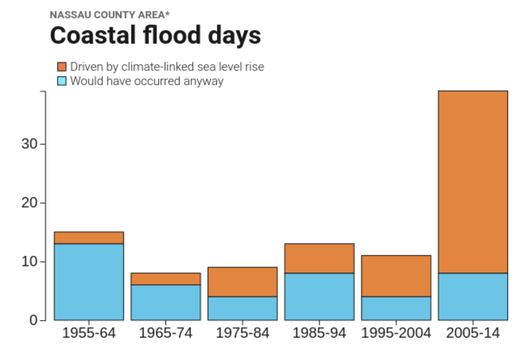 Coastal flood days in Nassau County, categorized as floods driven by climate-linked sea level rise or those that would have occurred anyway. Source: Surging Seas Risk Finder Climate changes and the local environment:For coastal communities such as New York City, global warming is a particularly pressing threat and its effects have already been experienced. Over the past century, the concentration of greenhouse gases in the atmosphere has increased, thus raising the global average temperature. With temperatures rising, sea levels rise as well. Global sea level rise can be attributed to two main factors: Arctic ice caps are melting, and oceans are warming thus expanding in volume. Rising sea levels have left New York City vulnerable to floods and storm surges. Historically, one important line of defense for these coastal areas have been salt marshes, which are estuaries where fresh and saltwater mix. Jamaica Bay is an estuary that can be found in the highly urbanized intersection between the Brooklyn and Queens boroughs, and is particularly valuable for both the humans and the natural environment. 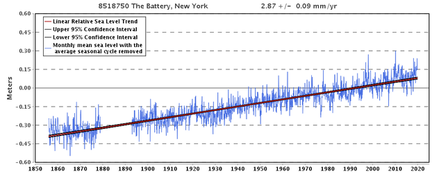 Changes in sea level in The Battery, New York from 1855 through today. Source: NOAA Tides and Currents. 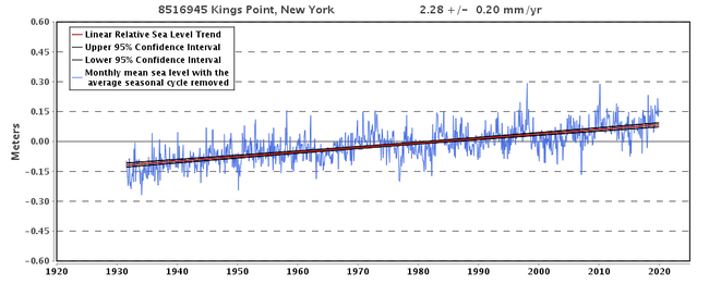 Changes in sea level in Kings Point, New York from 1930 through today. Source: NOAA Tides and Currents. During the last one hundred years alone, local sea levels have risen by nearly 30cm in New York City, with the rate of sea level rise in Jamaica Bay being almost twice the mean global rate. These two graphs, taken from NOAA’s Tides and Currents website, depict historic sea level is rise in Kings Point and The Battery in New York City. This data can be used to extrapolate the changes in sea level for Jamaica Bay, due to their proximity and similar conditions to the salt marsh. Salt marshes like Jamaica Bay provide some protection from the effects of sea level rise by slowing wave velocity, absorbing excess rainwater, and mitigating storm surges. They also protect shorelines from erosion by buffering wave action and trapping sediments. Additionally, they provide numerous other ecological benefits such as high biodiversity, improved water quality, flood reduction, and carbon sequestration. 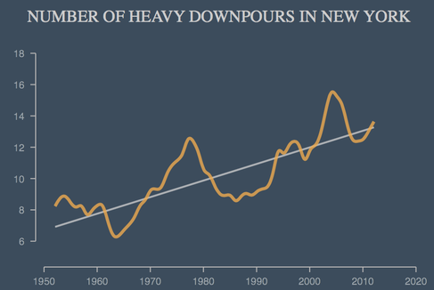 Graph displaying the overall upward trend of severe storms in New York from the 1950's to the present. Source: Climate Central. In addition to contributing to sea level rise, warming temperatures lead to an increase in evaporation, and thus, an increased frequency in storm events. Higher sea levels and storm events work synergistically – the greater the sea level rise, the more flooding each storm will bring, as well as more wave intensity and greater erosion. With New York City seeing a 350% increase in heavy downpours since 1950, marshes like those in Jamaica Bay have become increasingly vulnerable to erosion and floods from these worsening storms. How we know:This information relies on data from easily two accessible online tools, including the National Oceanic and Atmospheric Administration (NOAA) Tides and Currents tool and Climate Central’s Surging Seas: Risk Finder projections. It also uses data from a Climate Central research report. The NOAA Tides and Currents resource reports local mean sea level changes from 1850 to today. It uses data collected from U.S. and global water level stations to reconstruct local sea level trends. Climate Central’s Surging Seas tool generates projections for sea level rise and flood risks, which are based on the different emissions scenarios presented in the NOAA Technical Reports. The tool additionally shows the floods that coastal locations have experienced, distinguishing between which floods are driven by climate-linked sea level rise and which would have occurred naturally. Climate Central’s Heaviest Downpours research report displays the increase in heavy downpours in the United States. At each station, a heavy downpour was defined as the top 1 percent daily precipitation amounts over the period from 1950 to 2014. The analysis is based on precipitation observations from 2,962 climate stations across the US. Human consequences:While salt marshes can be quite resilient to sea level rise, Jamaica Bay experiences a variety of other stressors that make it particularly vulnerable to this threat. Factors that exacerbate the already damaging effects of sea level rise include the general sediment deficit, a deepening of the Bay through dredging, waves generated by boat traffic, and excessive waterfowl grazing. While in less metropolitan areas, salt marsh loss can be compensated for by expanding the marsh onto adjacent upland or freshwater zones, Jamaica Bay shows the catastrophic repercussions of deteriorating salt marshes that have no hopes for expansion. Salt marshes in New York are one of the primary defenses against rising sea levels for coastal areas, but have been steadily deteriorating throughout the last several centuries. In New York State, salt marshes have reduced by 60% from 1780 to 1980. Field studies conducted in Jamaica Bay show that from 1989 to 2003, the Bay’s marshes were in rapid decline losing 13.4 ha/year. From 2003 to 2013, this has declined to 2.1 ha due to restoration efforts. While the expected rising sea levels and future storms provide significant cause for concern, particularly in the Jamaica Bay region, this estuary is also a fascinating example of resilience in the face of climate change. In 2012, Hurricane Sandy tore through the northeast, causing significant flooding and massive devastation to infrastructure and coastal lagoons in the New York City area. During Hurricane Sandy, Jamaica Bay experienced a storm surge of 8 to 10 feet during the worst of the storm. The damage felt after the storm was significant as well, with debris from destroyed homes and buildings coming from Queens and Brooklyn ultimately ending up in the Bay. Additionally, thousands of gallons of oil coming from home fuel tanks leaked into the area, creating yet another expense in the clean up after the storm. The massive damages that Jamaica Bay, and the New York region as a whole, experienced from Hurricane Sandy displayed how instrumental proper governance and human action are in dealing with natural emergencies. Disaster relief funds provided swift critical aid to the region; however, many of these efforts were contained to the short-term and were more of a response tactic, rather than a preventative measure. Despite the destruction New York City faced in 2012, human efforts have caused impressive improvement in the conditions of Jamaica Bay within the last two decades. Compared to 2003 when restorations first began, there has been a marked decrease in deterioration for the Bay. This ultimately was responsible for how swiftly the area recovered after Hurricane Sandy; however, constant monitoring is necessary, as even post-restoration, salt marsh loss continues to occur in the Bay. Considering how important Jamaica Bay has historically been for the economic, social, and ecological health of New York, it is imperative that a concerted effort be made to help inoculate this area from the threats of future climate change, as rising sea levels and stronger storms will likely increase the risks facing the region. Further reading:Five Years After Hurricane Sandy, NYC’s Coastal Communities Remain Vulnerable. Curbed New York Jamaica Bay Walloped by Hurricane Sandy. Queens Chronicle New York Today: A ‘Maritime Forest’ Where Sandy’s Waters Rose. New York Times Article Author: Nicole Sheynin, Georgetown University
Article Editor: Maddie Bowen, Georgetown University 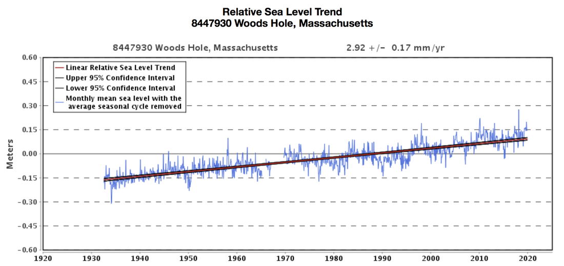 Changes in sea level in Woods Hole, Massachusetts from 1930 through today. Source: NOAA Tides and Currents. Climate change and the local environment:As atmospheric temperatures around the world soar, oceanic water temperatures are increasing too, and glaciers and ice sheets are melting. Because water molecules in warmer water exhibit greater molecular movement, water expands in volume as it heats up. Furthermore, melting polar ice adds to the amount of water not in ice sheets, again causing a rise in sea levels globally. Nonetheless, it is important to recognize that regional variations in atmospheric and oceanic circulation patterns, in addition to other factors, also influence the extent of sea level rise. As global sea levels continue to rise, exposed coastal communities must be prepared for an increased risk of flooding. Barnstable County, located on Cape Cod in Massachusetts, has already experienced a sea level increase of 11 inches since 1922, almost 2.85mm annually. Its vulnerable coastal position, located on 550 miles (890 km) of shoreline, contributes to the risk of flooding in the County in the face of sea level rise. 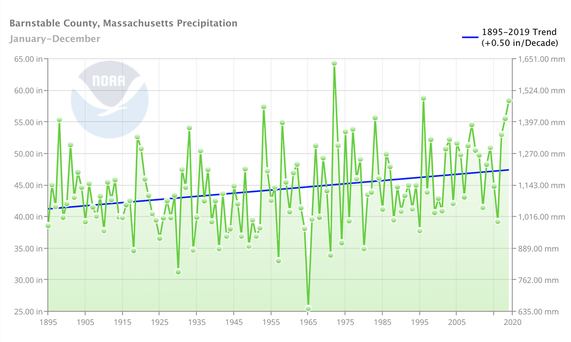 Average annual precipitation in Barnstable County from 1895 to the present. Source: NOAA Climate at a Glance. Barnstable County has also seen an upward trend in annual precipitation levels. As the atmosphere warms, the rate of evaporation increases. Quicker rates of evaporation pulls more water into the atmosphere which is then accessible for precipitation. Thus, the overall trend of atmospheric warming contributes to the rise in both frequency and intensity of precipitation events. Despite the annual variation in precipitation levels, the general progression seen over the past century in the graph above shows increasingly wetter conditions for Barnstable County. Hurricanes are also becoming more powerful as a consequence of warming global temperatures. Because hurricanes form over warm ocean waters, the increase in oceanic temperatures fuel hurricanes with more energy to activate higher peak winds and greater rainfall. Sea level rise also worsens the damages of hurricanes, as higher coastal inundation levels can increase the risk of storm-surge flooding. Although climate change does not necessarily impact the frequencies of hurricanes, it increases the severity of storms that have the potential to reach the coast of Cape Cod and cause tremendous damage. 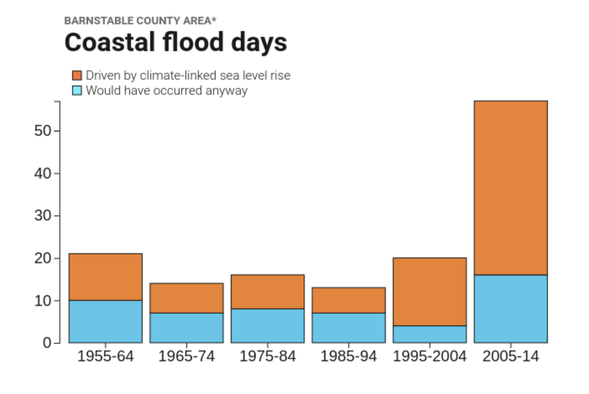 Coastal flood days in Barnstable County, categorized as floods driven by climate-linked sea level rise or those that would have occurred anyway. Source: Surging Seas Risk Finder The increased levels of precipitation, rising sea levels, and more powerful hurricanes have elevated the number of coastal flooding days in Barnstable County. These factors have not only made floods become more frequent, but have also made them more severe. The graph above shows the growing number of coastal flood days that can be linked to climate-driven sea level rise. The County has already experienced severe coastal flooding, and likely will suffer in the future as temperatures and sea levels continue to rise. How we know:This information relies on data from easily accessible online tools including the National Oceanic and Atmospheric Administration (NOAA) Tides and Currents tool, the NOAA Climate at a Glance resource, and Climate Central’s Surging Seas: Risk Finder projections. It also draws on conclusions from a NOAA study connecting hurricane severity to global warming. The NOAA Tides and Currents resource collects data from over 100 water level stations in order to reconstruct sea level trends at the local level. The NOAA Climate at a Glance tool generates graphs using data gathered from weather stations to show trends in temperature, precipitation, and drought on global, regional, and local scales. Climate Central’s Surging Seas projections display sea level rise and flood risks for coastal locations. Human consequences:Barnstable County acts as one of the biggest barrier islands in the world, shielding Massachusetts from the full weight of storms. Because of its location, the County’s shoreline is vulnerable to coastal flooding in the face of hurricanes. Even during small rain events, the Barnstable County drainage system is overwhelmed, resulting in the flooding of state roadways and personal properties. The heavy rainfall associated with severe hurricanes has caused especially severe flooding and significant property damage. Hurricanes throughout the 20th century have been tremendously destructive in Barnstable. The Great New England Hurricane of 1938 struck the Cape at a high tide, causing a storm surge of up to 15 feet. The devastating effects of the storm were felt throughout Barnstable County’s southern coast and into many of the inlets and bays. Parts of the County were flooded with up to 8 feet of water and struck with winds that reached over 120 mph, causing damage to houses, trees, and crops. With rainfall totaling over 17 inches, thousands of homes, businesses, and fishing fleets were destroyed or damaged from severe flooding. Barnstable County was again hit with a devastating hurricane in August of 1991, with Hurricane Bob damaging Buzzards Bay most significantly. Most of the County was under 5 to 10 feet of water, with wind gusts reaching over 120 mph. Many Massachusetts residents were left without power, and beaches suffered greatly from eroding coastlines. This hurricane forced a full evacuation in the height of the tourist season, shutting down the Cape for the rest of the summer and threatening the economic livelihood of many occupants. Hurricane Bob proved to be costly, with over $69 million in damages to public property, as well as $10 million of agricultural damages to local peach and apple orchards. The intensity of hurricanes and the risk of coastal flooding in Cape Cod has only increased throughout the past century. As temperatures warm and sea levels rise, these can only be expected to become more common and devastating in the future. While low cost flood insurance has been provided to the community, Barnstable County must decipher the best way to build up resilience in the face of the rising threat of climate change in order to keep its beloved coastal communities intact. Further reading:Barnstable County Multi-Hazard Mitigation Plan. Cape Cod Commission Massachusetts Hurricanes of the 20th Century. Massachusetts Office of Coastal Zone Management Cape Cod Climate Change. The Boston Globe Article Author: Maya Gibbs, Georgetown University
Article Editor: Maddie Bowen, Georgetown University 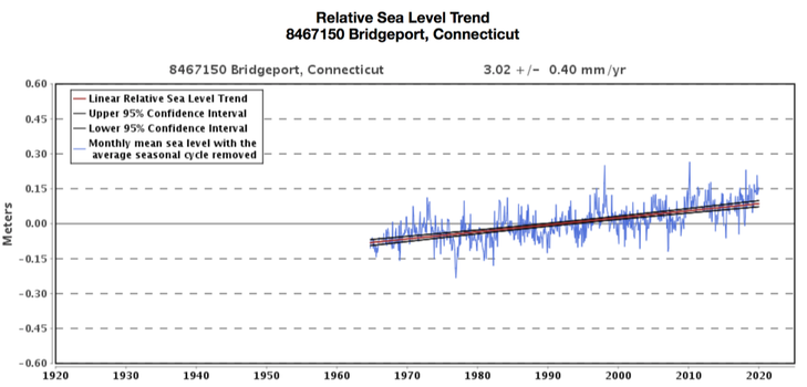 Changes in sea level in Bridgeport, Connecticut from 1920 through today. Source: NOAA Tides and Currents Climate changes and the local environment:Over the past century, warming oceans have significantly accelerated the melting of polar ice sheets, releasing trillions of tons of freshwater into the ocean. This melt, coupled with the increased volume occupied by warm water, has gradually raised sea levels in Fairfield County. 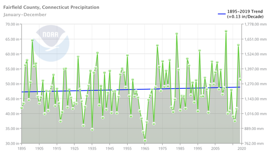 Average annual precipitation in Fairfield County from 1895 to the present. Source: NOAA Climate at a Glance. Bridgeport, one of largest cities in the county, has endured 5 inches of sea level rise since 1964. The county has also faced a real but erratic increase in annual precipitation. As global temperatures rise, the atmosphere is capable of holding more moisture, which in turn allows for more rainfall. 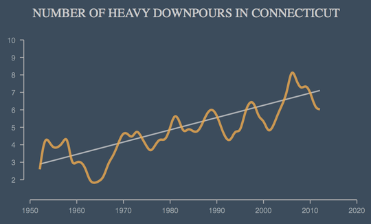 Graph displaying the overall upward trend of severe storms in Connecticut from the 1950's to the present. Source: Climate Central. More important than the modest trend in average precipitation in the county is a much more dramatic trend in heavy downpours since the 1950s. Torrential downpours, in addition to rising sea levels, have sharply increased the risk of flooding across Fairfield County. How we know: These reconstructions are based on easily-accessible online tools, including the National Oceanic and Atmospheric Administration’s (NOAA) Tides & Currents tool, the NOAA Climate at a Glance app, as well as Climate Central’s research report. NOAA’s Tides & Currents tool generates graphs of monthly mean sea levels for individual cities and counties. These graphs use sea level data collected from one of hundreds of sea level stations across the country, and include a long-term linear trend line. NOAA’s Climate at a Glance app uses data collected at weather stations and stored in NOAA's U.S. Climate Divisions database to create graphs about temperature, precipitation, and drought. This app can generate graphs that present global, regional, and local trends. Climate Central’s Heaviest Downpours research report displays the increase in heavy downpours in the United States. At each station, a heavy downpour was defined as the top 1 percent daily precipitation amounts over the period from 1950 to 2014. The analysis is based on precipitation observations from 2,962 climate stations across the US. Human consequences:Rising sea levels, an increase in overall precipitation, and more severe storms have greatly increased Fairfield County’s risk for floods. Over 130,000 people in the state are currently at risk of inland flooding, while heavy downpours and rising sea levels have strained the County’s sewer system. This stress on the County’s unprepared infrastructure has severely impacted both human and aquatic health. In particular, the rise in rain storms has increased levels of runoff. Within Fairfield County, the city of Bridgeport operates under a combined sewer system, meaning that rainwater runoff, domestic sewage, and industrial wastewater are all transported within the same pipe. During heavy storms where the rainfall exceeds the system’s capacity, the system is designed to overflow and release excess water into nearby bodies of water. These overflows, called combined sewer overflows (CSOs), have considerable impacts on the local environment of Fairfield County. CSOs present an environmental and public health risk for the County, as the untreated wastewater that is discharged can contain bacteria, raw sewage, excess nutrients from fertilizers, and chemicals. This particularly impacted Bridgeport, as portions of the city’s sewer system were built over 100 years ago. The Connecticut Department of Energy and Environmental Protection found that a CSO occurs whenever there is 0.4 inches of precipitation or more. Overflows from the system occur on average every 10 days, releasing between 100,000 and 500,000 gallons of contaminated water into local rivers, streams, and harbors. With the increasing rate at which heavy downpours are taking place in Bridgeport, this leaves the public exposed to bacteria and raw sewage, creating a considerable health risk. The increasingly high levels of contamination have also undermined recreational activity, often leading to the closure of multiple beaches and parks. In Bridgeport the following parks, beaches, and harbors are constantly affected: Ash Creek, Bridgeport Harbor, Black Rock Harbor, Pequonnock Harbor, Johnson’s Creek, Yellow Mill Pond, Cedar Creek, Burr Creek, and Island Brook. Moreover, the loss of fishing grounds in Bridgeport has greatly disturbed the fishing industry. Leaked sewage has and will continue to kill tens of thousands of acres of shellfish beds. Additionally, hypoxia, or the overgrowth of algae that leads to dangerously low levels of oxygen for aquatic life, will continue to appear throughout the County as excess fertilizers enter these ecosystems. These “dead zones” are detrimental for aquatic species and will only further degrade the County’s water quality. Fairfield County, and specifically the Bridgeport Water Pollution Control Authority (WPCA), have already taken measures to combat the damages from CSOs. The WPCA has developed a plan to minimize the number of CSOs, and has implemented green infrastructure to prevent or delay stormwater from entering the sewer system. Although these efforts have helped reduce the number of overflows, Fairfield County nevertheless must invest in more infrastructure and a new system in order to mitigate the damages caused by stormwater runoff and severe floods. Further reading:Some CT beaches considered among the dirtiest. EyeWitness News Water quality at Bridgeport, Fairfield beaches dropped in 2016. CT Post Bridgeport plans massive sewer upgrades. CT Post Combined Sewer Overflow Guide for City Employees. Bridgeport WPCA Article author: James Loughran, Georgetown University
Article editor: Maddie Bowen, Georgetown University 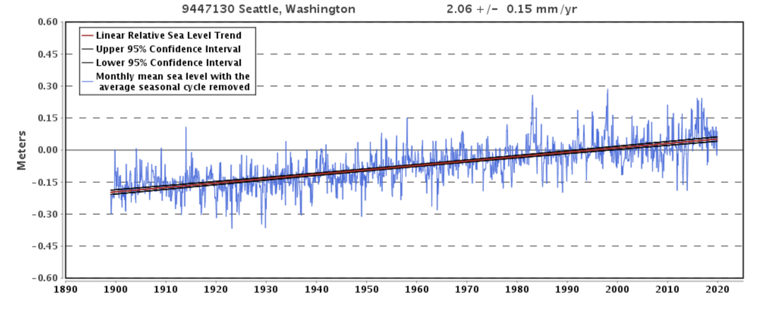 Changes in sea level in Seattle, Washington from 1900 through today. Source: NOAA Tides and Currents. Climate changes and the local environment:As the amount of greenhouse gases in the atmosphere has steadily increased within the past century, so has the average global temperature. This upward trend has contributed to a rise in global sea levels, as warmer average surface temperatures have increased oceanic temperatures. As the oceans warm, an increase in kinetic energy leads to thermal expansion of the water. Thus, this increase in molecular movement causes an overall expansion of the ocean’s volume. Additionally, rising global temperatures have accelerated the melting of Arctic ice caps, again contributing to global sea level rise. King County, situated on the coast of Washington state, is especially vulnerable to the effects of global sea level rise. The County has experienced an average increase in sea level of approximately 2.06mm per year, meaning there has already been an 8 inch rise in sea levels since the beginning of the 20th century. Due to its coastal location, rising sea levels have contributed to an increase in the intensity and frequency of major floods in King County. 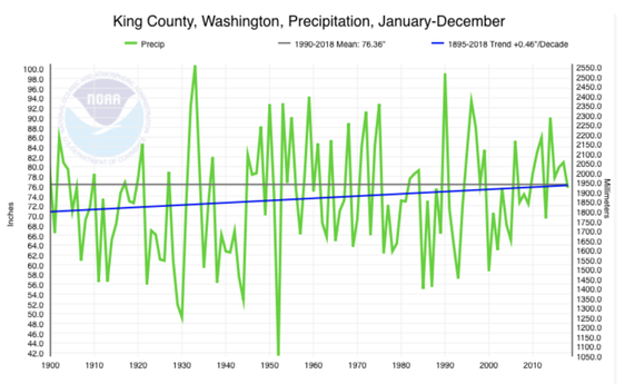 Average annual precipitation in King County from 1900 to the present. Source: NOAA Climate at a Glance. Additionally, the County has seen an overall rise in annual precipitation levels and a higher frequency of precipitation events. As temperatures rise, the warming atmosphere is capable of holding more moisture, contributing to this gradual increase in rainfall. This graph shows the annual level of precipitation in King County, illustrating that although there has been an annual variability of precipitation events, there is a distinct upward trend towards wetter conditions in the Seattle area. 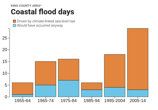 Coastal flood days in King County, categorized as floods driven by sea level rise or those that would have occurred anyway. Source: Surging Seas Risk Finder Rising sea levels combined with higher levels of precipitation have made floods much more common in King County. These conditions have contributed not only to an increase in the number of floods, but also in their severity. Since the 1950’s, the number of coastal flood days has increased, with a growing percentage of floods that can be largely attributed to sea level rise. Additionally, as temperatures have increased, more precipitation has fallen as rain rather than snow. This has caused worse fall and winter flooding of the County’s major rivers. Accordingly, the County has experienced a greater number of severe river floods, as well as coastal landslides from greater soil saturation levels, and urban flooding due to insufficient stormwater drainage systems. How we know:These reconstructions rely on data from several tools which are easily accessible online, including the National Oceanic and Atmospheric Administration (NOAA) Tides and Currents resource, the NOAA Climate at a Glance tool, as well as Climate Central’s Surging Seas: Risk Finder projections. The NOAA Tides and Currents resource uses data collected from over 140 long-term water level stations to reconstruct local sea level trends. These measurements are averaged monthly in order to present an accurate linear sea level trend. The NOAA Climate at a Glance tool uses data collected from weather stations to generate graphs that display past changes in temperature, precipitation, and droughts. The tool presents data that varies from the global averages to averages for individual counties and cities. Climate Central’s Surging Seas tool generates projections for sea level rise and flood risks, which are based on the different emissions scenarios presented in the NOAA Technical Reports. The tool additionally shows the floods that coastal locations have experienced, distinguishing between which floods are driven by climate-linked sea level rise and which would have occurred naturally. Human consequences:King County includes over 200 miles along the water of Puget Sound and Lake Washington, making floods a continual threat. As flooding has become more common and more dangerous, the local government has already implemented methods to reduce the impacts of severe flooding. In the 1950’s and 1960’s, the County built flood mitigation structures, such as dams and levees. Yet, these measures failed to decrease the hazards of coastal and urban floods. The Seattle government then emphasized non-structural mitigation strategies, including but not limited to offering flood insurance and placing greater restrictions on land use planning. In the past several decades after these initiatives were implemented, the flood risk in King County has significantly increased and demanded different preventative measures and solutions. Seattle constructed diversions and detention basins to slow and store stormwater; however, these do not fully minimize the threats of landslides, repair the damages from erosion from coastal flooding, or adequately prevent urban flooding. In January of 2009, King County experienced severe flooding after two days of heavy rain and warm temperatures that melted pre-existing snow. Rain total estimates from the Community Collaborative Rain, Hail, and Snow Network ranged from 1.5-2 inches in the western side of the county and 3-5 inches in the eastern section. This rainfall and snowmelt contributed to overflowing rivers in King County, even damaging the Howard Hanson Dam due to severe flooding of the Green River. The local impacts of the 2009 flood were extensive, with King County declaring a state of emergency and ordering its citizens to evacuate. Major highways were shut down due to the threat of landslides, and the National Guard worked to remove snow from roofs to prevent them from collapsing during the most intense stages of rainfall. Additionally, an estimated 6,000 structures, 5,000 of which were homes, were left isolated due to flood waters and landslides. These residents ultimately required emergency rescues in order to evacuate. Overall, this flood caused an estimated $96 million of damages in Washington state, with $28 million of damages in King County alone. As severe flood events have become increasingly common in Washington, King County adopted a new flood hazard management plan in 2013. The four main goals of this plan include protecting public safety, preventing property damage, recovering the declining salmon populations, and supporting recreation. The County also implemented policies to repair levees and other structural preventative measures along the coast. Additionally, King County plans to fund projects to minimize damages from coastal erosion, to maintain flood management facilities, and to increase local flood-preparedness education. The risk for severe flooding in the Seattle area has significantly increased in the past century, and major floods will only become more common and dangerous in the future. King County must decide how they will prepare for such events and how they will repair afterwards, as they have not yet discovered a sufficient method to respond to this environmental threat. Further reading:Seattle Hazard Identification and Vulnerability Analysis. Seattle Emergency Management January 2009 Flooding. Office of the Washington State Climatologist King County Flood Hazard Management Plan. King County Department of Natural Resources and Parks Article author: Maddie Bowen, Georgetown University
Article editor: Maddie Bowen, Georgetown University 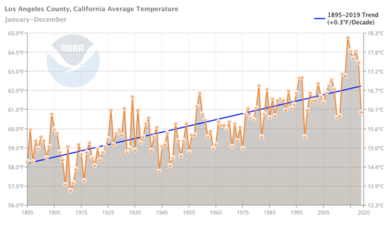 Average annual temperatures in Los Angeles County from 1895 to 2020. Source: NOAA Climate at a Glance. Climate changes and the local environment:Within the past century, the average temperature in Los Angeles County has increased by 3˚C. The number of days with a maximum temperature above 90˚ F has increased steadily over the past 20 years and is projected to continue rising. In addition to warmer average temperatures, Los Angeles County has experienced a decrease in precipitation during the fall and winter seasons. Increasing temperatures and decreasing levels of precipitation have increased the County’s risk for more severe droughts, as well as wildfires. 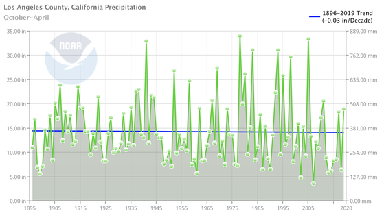 Average precipitation during the months of October to April in Los Angeles County from 1895 to 2020. Source: NOAA Climate at a Glance. Los Angeles County receives the majority of its annual rainfall during the late fall through early spring, then experiences a dry season during the summer months. The amount of winter season precipitation Los Angeles experiences has decreased over the past century, and this decline is predicted to continue. This reduction in rainfall means that there is less moisture in the soil at the beginning of the summer, which is the County’s dry season. The water evaporates from the soil and plants during the summer, and less winter precipitation ultimately leaves the vegetation drier earlier in the year. 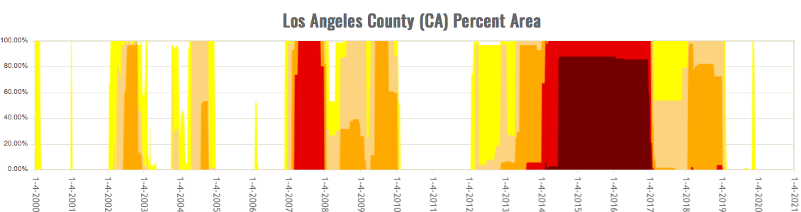 Drought severity in Los Angeles County from 2000 to 2020. Darker colors represent more severe droughts. Source: United States Drought Monitor. In addition to lower levels of rainfall, rising temperatures are reinforcing dryer and hotter summers in Los Angeles County. Higher annual temperatures lead to earlier snowpack melting, meaning that the winter season is shorter, there is less moisture in the soil during the dry season, and that the dry season is even longer. Warming temperatures also speed up evaporation, thus drying out the soil and parching the trees and vegetation. Drier and hotter summers have increased Los Angeles County’s drought risk, and by 2050 California’s risk of summertime drought is expected to almost triple. California’s dry and hot summers have always made the state more vulnerable to wildfires; however, rising temperatures and lower levels of precipitation have made the fire seasons longer and more severe. Los Angeles County’s fire season has already lengthened by approximately 75 days, and will likely increase in the future as well. With a longer and wetter winter season, Los Angeles County’s vegetation would soak up moisture which could help prevent summertime wildfires. This moisture dried out slowly through the summer season until it could be replenished the following fall. However, because the summer season has grown longer and hotter, and fall and winter rainfalls have decreased, flammable tinder has accumulated to high levels. Moreover, fire suppression over the last several decades has only added to the dangerous levels of tinder that has been available, and will continue to be available, to burn. How we know:These reconstructions are based on two easy to use tools that are freely accessible online: the National Oceanic and Atmospheric Administration (NOAA) Climate at a Glance tool and National Drought Mitigation Center's United States Drought Monitor. NOAA's Climate at a Glance tool uses data collected at weather stations and stored in NOAA's U.S. Climate Divisions database. This data is used to generate graphs about temperature, precipitation, and droughts, with the ability to look at global, national, and local averages. The Drought Monitor produces maps of drought conditions across the United States and publishes them weekly. The tool combines climate, soil, and water data with reports from 350 experts across the country. This generates an assessment of current drought conditions nationally, with the ability to look at data for individual states or counties. Human consequences:Warmer average temperatures, dryer seasons, and changing seasonal time frames have increased the number of wildfires in Los Angeles County, as well as in the intensity of the flames. Of the 20 largest fires to ever occur in California, two of them occurred in the last 10 years in Los Angeles County: the Thomas Fire in 2017 and the Station Fire in 2009. Over the past 50 years, summertime forest fires in the state have increased in size by approximately 800%, and 11.2 million residents in California currently live in areas with elevated risk for wildfires. Residents of Los Angeles County have already experienced the severe impacts of these wildfires. Wildfires release toxic smoke into the air, leaving dangerous air quality conditions, ash, and debris in their wake. Additionally, as wildfires rapidly spread, citizens can be forced to evacuate and in the worst situations, can lose their properties and homes to the fires. In 2018, the worst year of California wildfires on record, fires destroyed over 24,000 homes and buildings in the state. This increased risk of fire damage to residents’ homes has increased economic inequality in Los Angeles County, as wealth significantly enhances one’s possible response to wildfires. As early as 2005, wealthy individuals have been able to sign up for Private Fire Protection Services, typically at a high cost. While most individuals affected by fires were forced to flee their homes, wealthy individuals were able to wait out wildfires in luxury hotels while private firefighters worked to defend their properties from impending flames. This disparity was evident during the most recent Thomas Fire in 2017, when farm-owners left their properties to seek safety and returned to find their crops — and ultimately their livelihoods — destroyed. At the same time, many wealthy celebrities returned to their mansions on the beach, next-door to the farmers, with their properties untouched by the flames. Some climate activists have begun to refer to this emerging phenomenon as an impending “disaster apartheid.” As climate change continues to exacerbate wildfires and natural disasters become more frequent, there is a worry that a divide will form between “common” middle- and lower-class individuals and the wealthy elite. Los Angeles County will need to work especially hard in the near future to ensure that wealth does not drive a further wedge between its residents in the face of climate change. Further reading:California's New Normal: How the Climate Crisis is Fueling Wildfires and Changing Life in the Golden State. CNN California Wildfire Preparedness. States At Risk Why Does California Have So Many Wildfires? The New York Times Article Author: Benny Weisman, Georgetown University
Article Editor: Maddie Bowen, Georgetown University 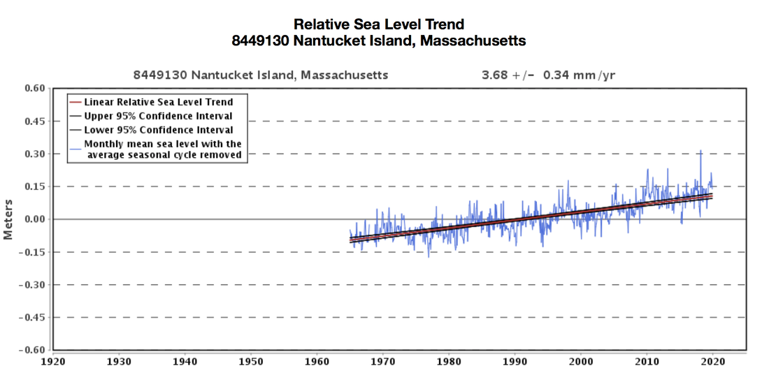 Changes in sea level in Nantucket County, Massachusetts from 1965 through today. Source: NOAA Tides and Currents. Climate changes and the local environment:As the amount of greenhouse gases in the atmosphere continues to increase, the average global temperature will increase as well. With an intermediate-low emission scenario, it is predicted that we could see an increase of 2 ̊C by 2100. Under the most extreme emissions scenario, average annual temperatures could rise by up to 4 ̊C in the coming century. Both emissions scenarios – either a 2 ̊C or 4 ̊C increase – will lead to global sea level rise. This increase in sea levels has two direct causes. First, thermal expansion of the world’s oceans occurs as average global temperatures, and thus oceanic temperatures, rise. This leads to an increase in kinetic energy of the water. This increase in molecular movement then causes an expansion in the water’s volume. Second, rising temperatures will speed up the melting of ice caps in Greenland and Antarctica. This melting will add more water to the Earth’s oceans and raise sea levels. Nantucket Island will continue to face extreme regional impacts as sea levels continue to rise. Given its location as an island off the coast of Massachusetts, Nantucket is especially susceptible to the effects of rising sea levels. If global temperatures increase by 2°C, Nantucket could see up to 10 feet of sea level rise. If temperatures increase by 4°C, oceans surrounding the County could rise by as much as 19 feet. In both emissions scenarios, all of historic Nantucket - a community hundreds of years old - would be underwater; however, with a rise in sea levels of 19 feet, a significant portion of the island could become submerged. 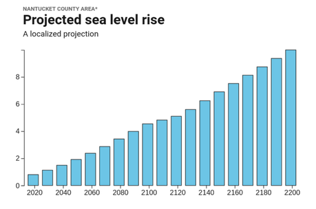 Projected sea level rise in Nantucket County under an intermediate-low emissions scenario. Source: Surging Seas Risk Finder. 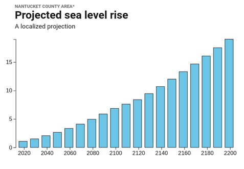 Projected sea level rise in Nantucket County under a high emissions scenario. Source: Surging Seas Risk Finder. The impacts of rising sea levels in Nantucket County will be intensified by coastal erosion. Nantucket is already losing coastal land at alarming rates due to the weathering of shorelines, a phenomenon exacerbated by potentially worsening hurricanes. Additionally, Nantucket County is an island composed of compacted sand, only making it more susceptible to coastal erosion. Portions of the island’s shorelines have already lost more than one hundred feet of coast depth in just the past decade. As global temperatures continue to rise, it will not just cause much of Nantucket to be below sea level, it will also speed up the erosion process until the island itself could cease to exist. How we know:These projections primarily rely on the free and easily accessible Tides and Currents tool by The National Oceanic Atmospheric Administration (NOAA) and Climate Central’s Surging Seas: Risk Finder projections. NOAA’s Tides and Currents resource uses data collected from over 140 long-term water level stations to reconstruct local relative sea level trends. These measurements are averaged monthly in order to present an accurate linear sea level trend. Climate Central’s Surging Seas: Risk Finder generates projections for sea level rise, as well as flood risks, based on the different emissions scenarios in the NOAA Technical Reports. This tool generates the projections for Nantucket County using data from the Nantucket sound water level station, located 2 miles from central Nantucket. Human consequences:The year-round population in Nantucket County is approximately 12,000 individuals; however, due to tourism, the population swells to 60,000 during the summer months. The County has more than 800 buildings and structures which were built before the Civil War and are historically preserved through the island’s local governance. The majority of these preserved buildings were built around Nantucket Harbor, the historic hub of the island’s once-famous whaling industry. It is this harbor, along with the surrounding historic buildings, that will likely be submerged underwater, with even a 2°C global temperature increase, if decisive actions are not taken. Additionally, the majority of the County’s prime real estate is located along the coast. Under a low emissions scenario, the total value of homes in Nantucket at risk of rising sea levels and increased floods could reach $990,000,000 by 2050. As a result of the severe erosion that Nantucket has already experienced, many of the island’s most valuable properties and historic landmarks - including some of the United States’ oldest lighthouses - have had to undergo relocation. Moving these properties to inland sites will temporarily protect the structures, but this process has cost residents on the island millions of dollars and, if sea levels continue to rise, will result in future costs for decades to come. The most recent and effective, yet expensive, solution to this problem is the installation of geotubes. Geotubes are two hundred feet long, seven-and-a-half feet tall, and 20 feet wide. Stacked four high, they line the island’s beaches where erosion is most severe. While designed to withstand the force of the nonstop waves and stay firmly in place, the geotubes are covered with additional sand to make the engineered bluff look as natural as possible. Geotube sand coverage also contributes sand to the natural erosion process without risking further destruction of the island’s beaches. Ultimately, Nantucket County’s fate depends greatly on how quickly and effectively measures can be taken to combat rising global temperatures and sea level rise. If emissions continue at the current rate, Nantucket Island will likely cease to exist and with it, the highly lucrative tourism industry and centuries of history. Further reading:Nantucket's Bluffs and Beaches are Crumbling in the Face of Storms and Rising Seas. PRI Chronicle: Fighting Erosion on Nantucket. WCVB More Details on Geotubes. Siasconset Beach Preservation Fund Article author: Benny Weisman, Georgetown University
Article editor: Maddie Bowen, Georgetown University |
 RSS Feed