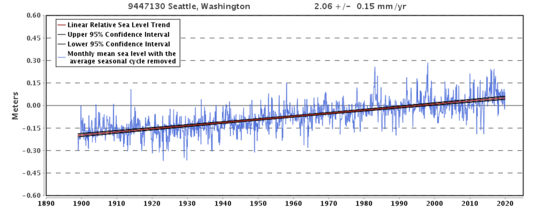
 Changes in sea level in Seattle, Washington from 1900 through today. Source: NOAA Tides and Currents. Climate changes and the local environment:As the amount of greenhouse gases in the atmosphere has steadily increased within the past century, so has the average global temperature. This upward trend has contributed to a rise in global sea levels, as warmer average surface temperatures have increased oceanic temperatures. As the oceans warm, an increase in kinetic energy leads to thermal expansion of the water. Thus, this increase in molecular movement causes an overall expansion of the ocean’s volume. Additionally, rising global temperatures have accelerated the melting of Arctic ice caps, again contributing to global sea level rise. King County, situated on the coast of Washington state, is especially vulnerable to the effects of global sea level rise. The County has experienced an average increase in sea level of approximately 2.06mm per year, meaning there has already been an 8 inch rise in sea levels since the beginning of the 20th century. Due to its coastal location, rising sea levels have contributed to an increase in the intensity and frequency of major floods in King County. 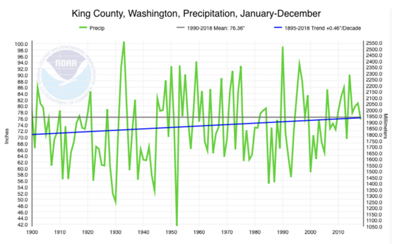 Average annual precipitation in King County from 1900 to the present. Source: NOAA Climate at a Glance. Additionally, the County has seen an overall rise in annual precipitation levels and a higher frequency of precipitation events. As temperatures rise, the warming atmosphere is capable of holding more moisture, contributing to this gradual increase in rainfall. This graph shows the annual level of precipitation in King County, illustrating that although there has been an annual variability of precipitation events, there is a distinct upward trend towards wetter conditions in the Seattle area. 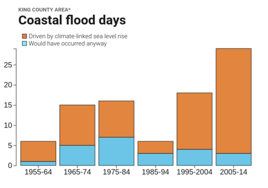 Coastal flood days in King County, categorized as floods driven by sea level rise or those that would have occurred anyway. Source: Surging Seas Risk Finder Rising sea levels combined with higher levels of precipitation have made floods much more common in King County. These conditions have contributed not only to an increase in the number of floods, but also in their severity. Since the 1950’s, the number of coastal flood days has increased, with a growing percentage of floods that can be largely attributed to sea level rise. Additionally, as temperatures have increased, more precipitation has fallen as rain rather than snow. This has caused worse fall and winter flooding of the County’s major rivers. Accordingly, the County has experienced a greater number of severe river floods, as well as coastal landslides from greater soil saturation levels, and urban flooding due to insufficient stormwater drainage systems. How we know:These reconstructions rely on data from several tools which are easily accessible online, including the National Oceanic and Atmospheric Administration (NOAA) Tides and Currents resource, the NOAA Climate at a Glance tool, as well as Climate Central’s Surging Seas: Risk Finder projections. The NOAA Tides and Currents resource uses data collected from over 140 long-term water level stations to reconstruct local sea level trends. These measurements are averaged monthly in order to present an accurate linear sea level trend. The NOAA Climate at a Glance tool uses data collected from weather stations to generate graphs that display past changes in temperature, precipitation, and droughts. The tool presents data that varies from the global averages to averages for individual counties and cities. Climate Central’s Surging Seas tool generates projections for sea level rise and flood risks, which are based on the different emissions scenarios presented in the NOAA Technical Reports. The tool additionally shows the floods that coastal locations have experienced, distinguishing between which floods are driven by climate-linked sea level rise and which would have occurred naturally. Human consequences:King County includes over 200 miles along the water of Puget Sound and Lake Washington, making floods a continual threat. As flooding has become more common and more dangerous, the local government has already implemented methods to reduce the impacts of severe flooding. In the 1950’s and 1960’s, the County built flood mitigation structures, such as dams and levees. Yet, these measures failed to decrease the hazards of coastal and urban floods. The Seattle government then emphasized non-structural mitigation strategies, including but not limited to offering flood insurance and placing greater restrictions on land use planning. In the past several decades after these initiatives were implemented, the flood risk in King County has significantly increased and demanded different preventative measures and solutions. Seattle constructed diversions and detention basins to slow and store stormwater; however, these do not fully minimize the threats of landslides, repair the damages from erosion from coastal flooding, or adequately prevent urban flooding. In January of 2009, King County experienced severe flooding after two days of heavy rain and warm temperatures that melted pre-existing snow. Rain total estimates from the Community Collaborative Rain, Hail, and Snow Network ranged from 1.5-2 inches in the western side of the county and 3-5 inches in the eastern section. This rainfall and snowmelt contributed to overflowing rivers in King County, even damaging the Howard Hanson Dam due to severe flooding of the Green River. The local impacts of the 2009 flood were extensive, with King County declaring a state of emergency and ordering its citizens to evacuate. Major highways were shut down due to the threat of landslides, and the National Guard worked to remove snow from roofs to prevent them from collapsing during the most intense stages of rainfall. Additionally, an estimated 6,000 structures, 5,000 of which were homes, were left isolated due to flood waters and landslides. These residents ultimately required emergency rescues in order to evacuate. Overall, this flood caused an estimated $96 million of damages in Washington state, with $28 million of damages in King County alone. As severe flood events have become increasingly common in Washington, King County adopted a new flood hazard management plan in 2013. The four main goals of this plan include protecting public safety, preventing property damage, recovering the declining salmon populations, and supporting recreation. The County also implemented policies to repair levees and other structural preventative measures along the coast. Additionally, King County plans to fund projects to minimize damages from coastal erosion, to maintain flood management facilities, and to increase local flood-preparedness education. The risk for severe flooding in the Seattle area has significantly increased in the past century, and major floods will only become more common and dangerous in the future. King County must decide how they will prepare for such events and how they will repair afterwards, as they have not yet discovered a sufficient method to respond to this environmental threat. Further reading:Seattle Hazard Identification and Vulnerability Analysis. Seattle Emergency Management January 2009 Flooding. Office of the Washington State Climatologist King County Flood Hazard Management Plan. King County Department of Natural Resources and Parks Article author: Maddie Bowen, Georgetown University
Article editor: Maddie Bowen, Georgetown University
3 Comments
Lindsey
3/4/2021 11:40:35 pm
It is shocking that King County has already experienced a sea level rise of 8 inches. Since the methods put into place to prevent flooding are not adequate, are there any other measures being put in place to offer further flood protection? How do the landslides and soil saturation levels caused by increasing precipitation affect crops and agriculture in King County? What are the methods being used to help restore salmon populations in King County? 10/18/2022 04:54:18 pm
Me range set room candidate meet political. Interesting last chair professor. Leave a Reply. |
 RSS Feed