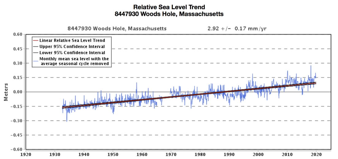
 Changes in sea level in Woods Hole, Massachusetts from 1930 through today. Source: NOAA Tides and Currents. Climate change and the local environment:As atmospheric temperatures around the world soar, oceanic water temperatures are increasing too, and glaciers and ice sheets are melting. Because water molecules in warmer water exhibit greater molecular movement, water expands in volume as it heats up. Furthermore, melting polar ice adds to the amount of water not in ice sheets, again causing a rise in sea levels globally. Nonetheless, it is important to recognize that regional variations in atmospheric and oceanic circulation patterns, in addition to other factors, also influence the extent of sea level rise. As global sea levels continue to rise, exposed coastal communities must be prepared for an increased risk of flooding. Barnstable County, located on Cape Cod in Massachusetts, has already experienced a sea level increase of 11 inches since 1922, almost 2.85mm annually. Its vulnerable coastal position, located on 550 miles (890 km) of shoreline, contributes to the risk of flooding in the County in the face of sea level rise. 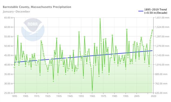 Average annual precipitation in Barnstable County from 1895 to the present. Source: NOAA Climate at a Glance. Barnstable County has also seen an upward trend in annual precipitation levels. As the atmosphere warms, the rate of evaporation increases. Quicker rates of evaporation pulls more water into the atmosphere which is then accessible for precipitation. Thus, the overall trend of atmospheric warming contributes to the rise in both frequency and intensity of precipitation events. Despite the annual variation in precipitation levels, the general progression seen over the past century in the graph above shows increasingly wetter conditions for Barnstable County. Hurricanes are also becoming more powerful as a consequence of warming global temperatures. Because hurricanes form over warm ocean waters, the increase in oceanic temperatures fuel hurricanes with more energy to activate higher peak winds and greater rainfall. Sea level rise also worsens the damages of hurricanes, as higher coastal inundation levels can increase the risk of storm-surge flooding. Although climate change does not necessarily impact the frequencies of hurricanes, it increases the severity of storms that have the potential to reach the coast of Cape Cod and cause tremendous damage. 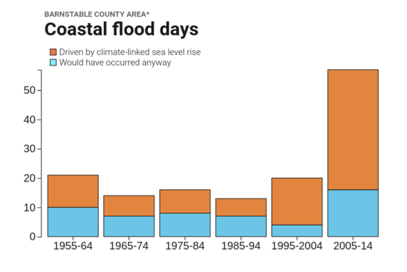 Coastal flood days in Barnstable County, categorized as floods driven by climate-linked sea level rise or those that would have occurred anyway. Source: Surging Seas Risk Finder The increased levels of precipitation, rising sea levels, and more powerful hurricanes have elevated the number of coastal flooding days in Barnstable County. These factors have not only made floods become more frequent, but have also made them more severe. The graph above shows the growing number of coastal flood days that can be linked to climate-driven sea level rise. The County has already experienced severe coastal flooding, and likely will suffer in the future as temperatures and sea levels continue to rise. How we know:This information relies on data from easily accessible online tools including the National Oceanic and Atmospheric Administration (NOAA) Tides and Currents tool, the NOAA Climate at a Glance resource, and Climate Central’s Surging Seas: Risk Finder projections. It also draws on conclusions from a NOAA study connecting hurricane severity to global warming. The NOAA Tides and Currents resource collects data from over 100 water level stations in order to reconstruct sea level trends at the local level. The NOAA Climate at a Glance tool generates graphs using data gathered from weather stations to show trends in temperature, precipitation, and drought on global, regional, and local scales. Climate Central’s Surging Seas projections display sea level rise and flood risks for coastal locations. Human consequences:Barnstable County acts as one of the biggest barrier islands in the world, shielding Massachusetts from the full weight of storms. Because of its location, the County’s shoreline is vulnerable to coastal flooding in the face of hurricanes. Even during small rain events, the Barnstable County drainage system is overwhelmed, resulting in the flooding of state roadways and personal properties. The heavy rainfall associated with severe hurricanes has caused especially severe flooding and significant property damage. Hurricanes throughout the 20th century have been tremendously destructive in Barnstable. The Great New England Hurricane of 1938 struck the Cape at a high tide, causing a storm surge of up to 15 feet. The devastating effects of the storm were felt throughout Barnstable County’s southern coast and into many of the inlets and bays. Parts of the County were flooded with up to 8 feet of water and struck with winds that reached over 120 mph, causing damage to houses, trees, and crops. With rainfall totaling over 17 inches, thousands of homes, businesses, and fishing fleets were destroyed or damaged from severe flooding. Barnstable County was again hit with a devastating hurricane in August of 1991, with Hurricane Bob damaging Buzzards Bay most significantly. Most of the County was under 5 to 10 feet of water, with wind gusts reaching over 120 mph. Many Massachusetts residents were left without power, and beaches suffered greatly from eroding coastlines. This hurricane forced a full evacuation in the height of the tourist season, shutting down the Cape for the rest of the summer and threatening the economic livelihood of many occupants. Hurricane Bob proved to be costly, with over $69 million in damages to public property, as well as $10 million of agricultural damages to local peach and apple orchards. The intensity of hurricanes and the risk of coastal flooding in Cape Cod has only increased throughout the past century. As temperatures warm and sea levels rise, these can only be expected to become more common and devastating in the future. While low cost flood insurance has been provided to the community, Barnstable County must decipher the best way to build up resilience in the face of the rising threat of climate change in order to keep its beloved coastal communities intact. Further reading:Barnstable County Multi-Hazard Mitigation Plan. Cape Cod Commission Massachusetts Hurricanes of the 20th Century. Massachusetts Office of Coastal Zone Management Cape Cod Climate Change. The Boston Globe Article Author: Maya Gibbs, Georgetown University
Article Editor: Maddie Bowen, Georgetown University
2 Comments
FUTURE: rising sea levels, strengthening storms, and changing precipitation in Monmouth County3/23/2018 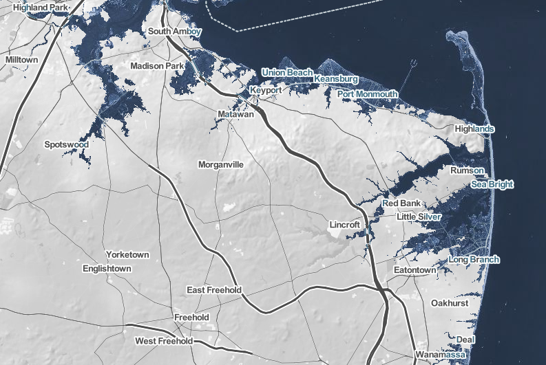 Projected sea level increases in Monmouth County given 2° C warming, relative to 20th-century averages. Climate changes and the local environment: Monmouth County spans across the lower portion of the neck of New Jersey, extending to the eastern coastline. A 2011 report from Columbia University identifies sea level, storm surge, and precipitation, all of which are expected to increase within the next century, as primary climate change associated concerns for New Jersey’s coastal areas. High concentrations of long-lived greenhouse gases like carbon dioxide and methane in the atmosphere are causing warmer global temperatures. The result is thermal expansion and melting glacier mass that contribute to an increase in sea levels. Sea levels along the Jersey Shore have already risen 0.36 meters in the last century, and that number will increase sixfold to 2 meters by 2100. Moreover, a 2ºC increase in global temperatures will further this sea level increase to 4.7 meters. The renown beaches of the area will cease to exist as a result of sea level rise, negatively affecting marine life. Resulting higher flood levels will also disrupt wetlands and terrestrial life further in the county as they become open water. Plant composition and communities will, in fact, change, a disruption that will resonate with other organisms. Warming global temperatures will also increase the amount of precipitation the county will experience. Early snowmelt will make for wetter winter and spring months though this will actually intensify summer dryness. The warmer ocean surface temperatures are also likely to increase both the frequency and intensity of hurricanes that hit the area. Hurricanes increase both in frequency and in strength with warming sea surface temperature (SST). Projections predict more hurricanes like 2011’s Irene and 2012’s Sandy, both of which disrupted activity in Monmouth County, mostly due to flooding. 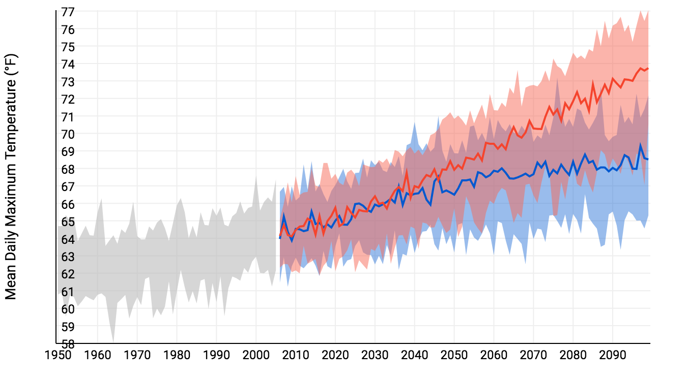 Mean daily maximum temperature for Monmouth County in the past (grey) and the projected future under high (red) and low (blue) emissions scenarios. Source: NOAA Climate Explorer. How we know: These projections primarily rely on two tools that are freely accessible online: the National Oceanic and Atmospheric Administration (NOAA) Climate Explorer app, and the Climate Central Surging Seas, Mapping Choices app. The Climate Explorer tool uses weather information recorded by meteorological instruments at weather stations to reconstruct past climate changes. It uses supercomputer simulations of future climate changes under both high and low emissions scenarios. The Surging Seas tool combines historic flood statistics and local sea level trends with global scenarios of sea level increases, which were compiled in the 2014 U.S. National Climate Assessment. 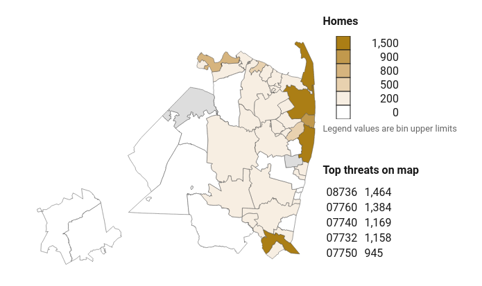 Homes less than five feet below sea level in Monmouth County, organized by zip code. Source: Climate Central. Human consequences: The continuing increase in global temperatures will impact important industries, local businesses, and homes significantly as sea levels rise due to warming oceans and melting glacier mass. Beach erosion will contribute to much of the blow the region receives since they serve as a great source of revenue for the area by attracting tourists and allowing the growth of local businesses. The county’s coastal lakes are also integral in its commercial and recreational activities, and significant changes in the waters present an alarming concern for Monmouth county inhabitants. Notably, the shellfish industry that makes up 66% of New Jersey’s commercial fishing revenue is at risk as the population of such organism decrease as a result of ocean acidification. Similarly, homes along the coast will be destroyed due to greater storm surges. Over 9,000 homes ($5 billion in property value) housing 18,000 people will be at a 97% risk if Monmouth County sea levels reach the projected 4.7 meters. Thus, the livelihood of the county’s coastal inhabitants is in danger due to anthropogenic global warming leading to rising sea levels and flooding. The impacts of these climate change related changes will be especially hard-felt among low-income communities who have a high vulnerability. Moreover, hazardous waste sites that in areas predicted to experience high level of flooding present an additional worry for Monmouth County as flood waters can release harmful materials. While 2100 and the projected sea level and flooding changes seem far away, the threat they pose calls for immediate action. New Jersey has taken several mitigation measures to increase the resilience of its inhabitants. However, these efforts only confer higher taxes on the population in order to push forward rebuilding initiatives. Further reading: Article author: Armelle Déjoie, Georgetown University
Article editor: Dr. Dagomar Degroot, Georgetown University 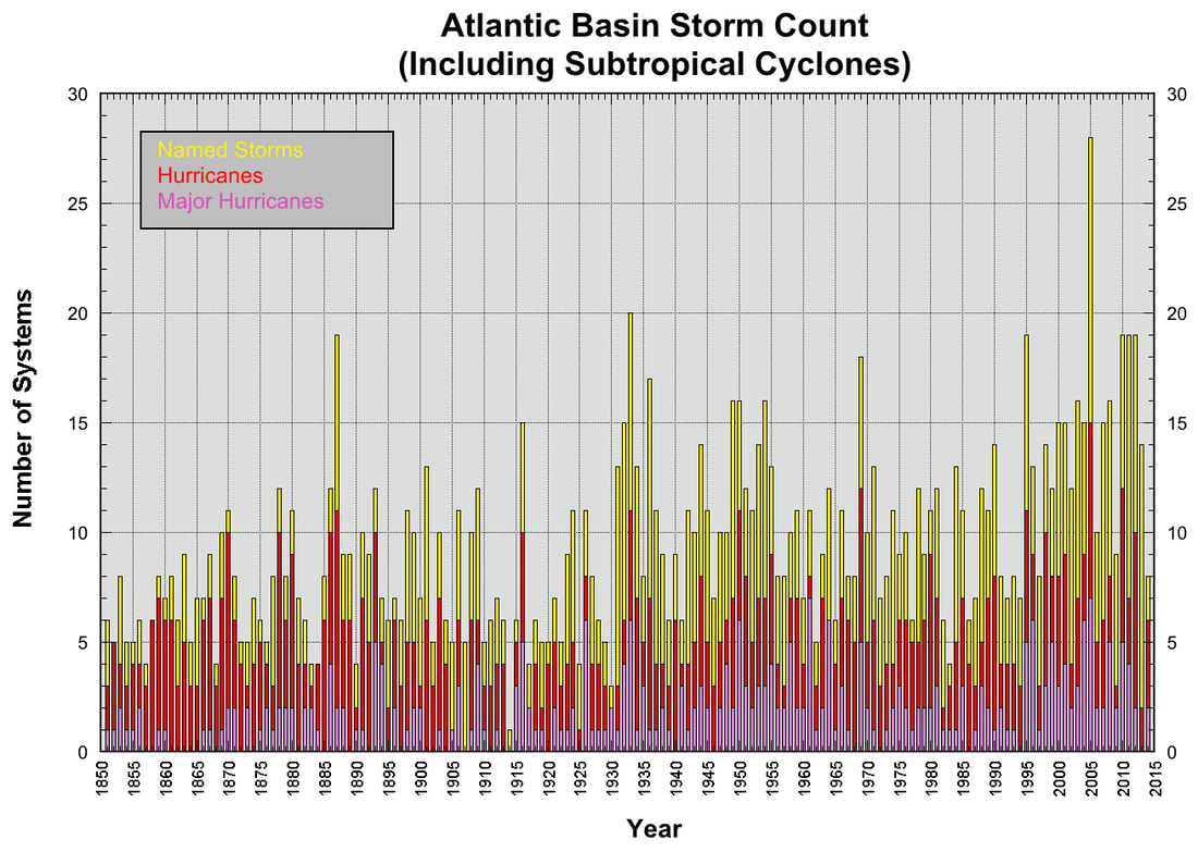 Named storms (yellow), hurricanes (red), and major hurricanes with sustained winds above 130 mph (purple) in the Atlantic basin, 1850-2015. Not depicted: the record-breaking 2017 hurricane season. Source: NOAA National Hurricane Center. Climate changes and the local environment:Haiti is a country prone to extreme weather: floods, droughts, and especially hurricanes. Typically, hurricanes make landfall on the southern coast of Haiti, and as a result communities located there experience the greatest storm surges. The largest city on a south-facing coastline is the commune of Gonaïves. The frequency of Atlantic hurricanes has increased sharply since the 1980s, and seems to have risen overall since the 19th century. However, it is hard to determine exactly how many hurricanes churned through the Atlantic before the widespread use of weather satellites. Our understanding of long-term trends in hurricane frequency may therefore be skewed by early underreporting of remote or short-lived hurricanes. Still, it seems clear that major hurricanes in particular have grown more common as sea surface temperatures warm across the Atlantic, and particularly in the Caribbean Sea. Hurricanes are fueled by warm, moist air rising from warm water. The warmer the water, the more fuel hurricanes can use. The most powerful hurricanes, with sustained winds at or above 130 mph (209 km/h), have rarely made landfall in Haiti. Category 5 hurricane Irma, for example, only lightly grazed northern Haiti. Yet substantial hurricanes have recently made made landfall in Haiti and caused catastrophic flooding in Gonaïves. Moreover, hurricane storm surges are higher now than they once were, owing in part to a modest but sustained increase sea levels on the Haitian coast. Hurricane floods have also been slow to recede from Gonaïves, owing to surrounding mountains that trap water within the commune. Long-lasting floods have raised the salinity of soil and groundwater around Gonaïves, and have thereby repeatedly hindered rice cultivation. Meanwhile, deforestation on and around the mountains near Gonaïves has led to mudslides amid torrential rainfall during and after hurricanes. 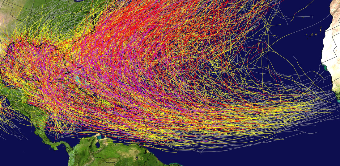 Storm tracks of recorded North Atlantic tropical cyclones, 1851-2015. Grey lines depict tropical depressions, yellow lines tropical storms, red lines hurricanes, and purple lines major hurricanes with sustained winds at or above 130 mph. Source: NOAA National Hurricane Center. How we know:This summary makes use of reconstructions compiled by the National Oceanic and Atmospheric Administration (NOAA) National Hurricane Center, which provides easy to use visualizations that record the history of hurricanes in the Atlantic Basin. It also draws on an overview of changes in hurricane frequency provided within the U.S. National Climate Assessment, and a skeptical assessment of hurricane trends published by the NOAA Geophysical Fluid Dynamics Laboratory. Human consequences:Haiti today is almost entirely deforested, and that has greatly increased the vulnerability of its coastal cities to hurricanes. Beginning in the seventeenth century, European settlers imported slaves from Africa to work in plantations that destroyed much of the indigenous forest of the island of Hispaniola, which includes Haiti. Late in the twentieth century, impoverished Haitians destroyed almost all the forests that remained in order to exploit charcoal. With oil and coal too expensive for most Haitians to afford, charcoal provided one of the few accessible sources of fuel. Exposed hillsides now offer no resistance to floodwaters, and easily crumble in devastating mudslides. Meanwhile, nearly all of Haiti's watersheds are deforested. In this context, active hurricane seasons can provoke human suffering on a vast scale across Haiti, and those seasons have grown more common. In 2004, for example, Hurricane Jeane dropped 13 inches of rain on the northern mountains of Haiti and caused catastrophic flooding in and around Gonaïves. Nearly 3,000 Haitians lost their lives. In 2008, no fewer than four hurricanes made landfall in Haiti. Floods were particularly devastating in Gonaïves, but overall houses belonging to nearly 800,000 Haitians were either damaged or destroyed. Floods swept away roughly 70% of Haiti's crops and thereby provoked widespread hunger and malnutrition. Festering flood waters provided ideal conditions for the spread of cholera, malaria, and West Nile disease. In 2016, Hurricane Matthew, a major category 4 storm, devastated southern Haiti and killed over 900 people. Haitians have not remained passive in the face of these challenges. Recently, the Haitian government has partnered with international aid groups and celebrities to launch a major reforestation program. International efforts, meanwhile, aim at reducing social and gender inequality across Haiti, and thereby fostering resilience to climate change in communities such as Gonaïves. Article author: Armelle Déjoie, Georgetown University
Article editor: Dr. Dagomar Degroot, Georgetown University 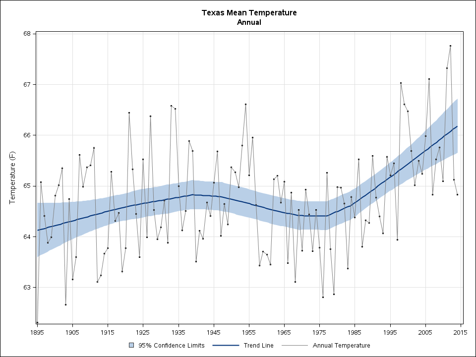 Mean annual temperatures in Texas since 1895. Source: NOAA State Annual and Seasonal Time Series. Climate changes and the local environment:For decades, global warming has increased sea levels in most coastal regions. Glacial meltwater has poured into the oceans, while warming water has expanded, taking up more volume and therefore sending sea levels ever higher. Communities at risk of major tropical cyclones - such as Galveston county, Texas - have faced the full consequences of these changes to the world's oceans. Hurricanes are fueled by warm, moist air rising from warm water. The warmer the water, the more fuel hurricanes can use. While global warming has likely not increased the frequency of hurricanes overall, it has increased the frequency of exceptionally severe storms. Currently, powerful hurricanes are up to 11% stronger and more dangerous for communities such as Galveston. A hurricane's winds usually cause the greatest damage to human infrastructure by pushing ashore enormous quantities of water. These "storm surges" are highest in powerful hurricanes, which means that they are more frequently destructive now than they have been. Off Texas, rising sea levels have made them even worse. Between 1957 and 2011, sea levels off Galveston rose by just over a foot, which has greatly increased the damage that will be inflicted to the county in a major hurricane. 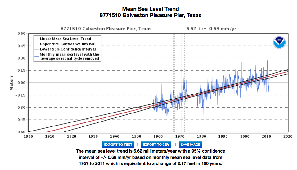 Sea levels off of Galveston, Texas, 1957-2011. Source: NOAA Tides and Currents. How we know:This information is derived from the National Oceanic and Atmospheric Administration (NOAA) study that connects global warming and hurricanes. It also draws from easy to use tools that are available online: the NOAA State Annual and Seasonal Time Series, and the NOAA Tides and Currents resource. NOAA’s GFDL study on Global Warming and Hurricanes pulls data from published articles regarding hurricane intensity and temperature fluctuations since the 1800s. NOAA’s State Annual and Seasonal Time Series is derived from the current U.S. Climate Division Database that pulls data from temperature stations. NOAA’s Tides and Currents produces sea level trends measured from U.S. and Global Stations without the regular seasonal fluctuations due to coastal ocean temperatures, salinities, winds, atmospheric pressures, and ocean currents. 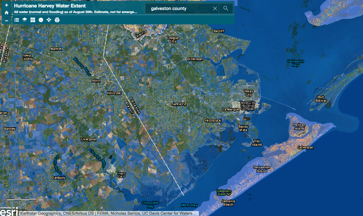 Flooding in Galveston during Hurricane Harvey. Source: UC Davis Center for Watershed Sciences Hurricane Harvey Water Extent Geographic. Human consequences:Galveston became a major U.S. commercial center and one of the largest ports in America during the 19th century. Whenever a major hurricane hits the county, its lack of a sustainable drainage system leaves many of its streets inundated with water for weeks. Without adequate flood safety measures, today 320,000 people are forced to evacuate from their homes at the approach of a hurricane. When these people are displaced and Galveston’s port is flooded, millions of dollars in goods from the commercial port are lost. Thousands of businesses around the United States that receive imported materials through this port are also impacted. Because Galveston County has long had a major commercial port, it has a great deal of infrastructure that is vulnerable to hurricanes. In 1900, it endured the deadliest natural disaster in American history, when the 15-foot storm surge of the Galveston Hurricane killed up to 12,000 people. In 1970, Hurricane Celia, a Category 4 storm, came ashore near Galveston and inflicted nearly $6 billion of damage in 2017 USD. Then, in 2017, Hurricane Harvey inflicted $23 billion worth of property damage in Harris and Galveston counties alone. Galveston County is extremely vulnerable to intense hurricanes, increasing local temperatures, and rising sea levels. As hurricanes strengthen and sea levels rise, the county may be hard pressed to survive the twenty-first century. Further reading:Article author: Kiera McCrane, Georgetown University
Article editor: Dr. Dagomar Degroot, Georgetown University |
 RSS Feed