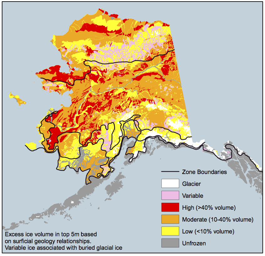
 Ice cover across Alaska in 2008. Source: University of Alaska Permafrost Laboratory. Climate changes and the local environment: Alaska is warming more than twice as quickly as the contiguous United States. Over the past 60 years, average annual temperatures in Alaska have increased by about 3°F. Winter warming has been even more extreme, with average seasonal temperatures rising by 6°F. Climate projections based on continuing high greenhouse gas emissions - known as "high emissions scenarios" - predict that average winter temperatures in towns across North Slope Borough in northern Alaska will rise by as much as 25°F in the coming century. By 2050, average annual temperatures across Alaska are expected to increase by 2 to 4°F. As Alaska continues to warm, melting sea ice and coastal erosion represent the two most pressing threats to North Slope Borough. Permafrost is a thick layer of soil, usually a foot or so down from the surface, that remains frozen year-round. Permafrost covers over 80% of Alaska, but that number is shrinking as rising temperatures cause permafrost to melt. When permafrost melts, the ground above it collapses, and methane enters the atmosphere. Methane is a potent greenhouse gas, and although it does not stay in the atmosphere for long when compared to carbon dioxide, it can cause profound regional warming. Thus because melting permafrost also increases atmospheric methane, rising temperatures will provoke even more warming and melting. Increasing temperatures will also melt sea ice on the coasts of Alaska. Models that match historical trends predict that, by 2030, the entire Arctic could be ice-free in the summer. Loss of sea ice is dangerous for ecosystems in North Slope Borough. In the colder past, sea ice acted as a natural barrier to storms and waves. However, as the sea ice melts and recedes from the coastline, wind and water erosion is projected to increase accordingly, especially during big storms. Permafrost also once protected the North Slope Borough coasts from erosion, but it may not for much longer. 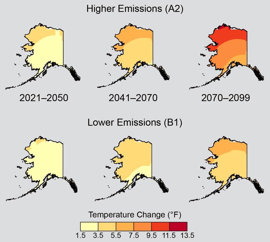 Average annual temperatures will increase across Alaska under all emissions scenarios. Warming will be especially rapid in Northern Alaska, including North Slope Borough. Source :U.S. Global Change Research Program. How we know: These predictions are largely based on two easy-to-use tools that are freely accessible online: the National Aeronautics and Space Administration’s (NASA) GISS Surface Temperature Analysis and the National Snow and Ice Data Center’s Arctic Sea Ice News and Analysis (NSIDC). The GISS Surface Temperature Analysis tool uses maps to show global temperature anomalies, comparing current temperatures to temperatures in the 1951-1980 period. Mean temperatures are averaged over a specific time period and interval, and the analysis is updated monthly. Data is compiled from the National Oceanic and Atmospheric Administration’s databases and satellites. The Arctic Sea Ice News and Analysis tool provides updates and scientific analysis on the conditions of Arctic sea ice. The website publishes graphs and animated visuals documenting the extent, depth, and concentration of sea ice. The tool is run by National Snow and Ice Data Center scientists, along with support from NASA. Human consequences: Future climate change will likely have devastating consequences for North Slope Borough and its residents. The imminent reality of a seasonally ice-free Arctic may sound like a desirable outcome at first, seeing that some economic opportunities such as faster shipping routes, oil and gas exploration, and tourism may become available. However, coastal villages, which represent many of the residences in North Slope Borough, will face one of two unfortunate realities as erosion threatens homes. At best, residents will be forced to relocate inland, and at worst, homes and even lives will be lost to the sea. More than 30 villages in North Slope Borough have already been identified for relocation. Indigenous lives are especially threatened as climate change continues in the coming century. Alaskan Iñupiat make up fifty-two percent of all residents in North Slope Borough, according to a 2016 census. Many rely on a subsistence diet and are therefore relatively vulnerable to sudden changes in their surrounding ecosystems. Whales and seals, which are hunted out on the sea ice, constitute the majority of the protein in local Iñupiat diets. With the sea ice retreating, the accessible supplies of fish, game, and whales will decline, and Iñupiat hunters will have to brave dangerously thin ice in hopes of catching food. Thawing permafrost may also undermine human health and economic growth in North Slope Borough. These problems will include a loss of clean water, saltwater intrusion, and the expansion of diseases northward into the warming climate. Many villages, especially those of lower income, dig holes into the permafrost and use these to dispose of and contain sewage; however, as the permafrost thaws, the sewage will leak out, resulting in contamination and the spread of disease. Thawing permafrost will also contribute to increasing pollutant exposure to residents, as the soil contains a significant amount of mercury and carbon dioxide. Additionally, thawing permafrost is projected to add up to $6.1 billion in maintenance costs, as the uneven sinking of the ground will disrupt existing infrastructure. Unfortunately, many of these events will occur even if warming is slowed by curbing emissions. Combating these changes will require both adaptation and resilience in North Slope Borough and beyond. Further reading: Alaska Regional Climate Projections. Scenarios Network for Alaska Planning. Alaska. U.S. Global Change Research Program Article author: Georgia Brainard, Georgetown University
Article editor: Dr. Dagomar Degroot, Georgetown University
10 Comments
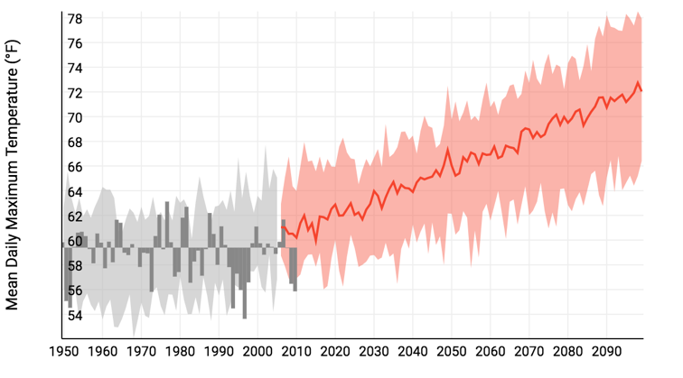 Predicted Mean Daily Maximum Temperatures (˚F) for Buffalo County under a High Emissions Scenario developed by NOAA’s Climate Explorer. Climate changes and the local environment: As the concentration of greenhouse gases increases, temperatures are expected to rise across the United States. Under a high emissions scenario, which occurs if greenhouse gas emissions continue to increase, Buffalo County could see an increase in mean daily maximum temperature from 61˚F to 72˚F by 2100. The average number of days with a minimum temperature below 32 ˚F between 1950 and 2004 was 168 days. This figure is projected to decrease to approximately 110 days by 2100. On the other hand, the number days with a maximum temperature above 95 ˚F will increase from 20 (1950 to 2004 average) to 70 days by 2100. This is significant as this represents an approximately 250% change in days with high heat. It should be noted that the specific figures for the predicted temperature changes are based on the median predicted value from all projections under the high emissions scenario. As the temperature increases, the amount of precipitation is also expected to rise by up to 35 percent, particularly in the spring, compared to the 1960-1970 average by 2080 under a high emissions scenario. However, a large portion of this increase will be accounted for by heavy downpours and more intense storms because as the air warms it is able to hold and then consequently release more water vapor. Because of this, Buffalo County will see an increase in both the risk and severity of summertime drought. The state of South Dakota is projected to see a 75% increase in its summer drought threat index. Additionally, the soil is expected to become drier as the warmer temperatures increase the rate of evaporation and water use by plants. Increased precipitation will only partially offset this because with a higher number of heavy precipitation events the ground will absorb less water and more will run off. The runoff, especially into the Missouri River, which borders Buffalo County, will increase the risk of inland flooding.  Predicted Days with a Maximum Daily Temperature Above 95 ˚F for Buffalo County under a High Emissions Scenario developed by NOAA’s Climate Explorer. How we know: The projections for temperature and precipitation come from the publically available US Climate Resilience Toolkit and Climate Explorer developed by the National Oceanic and Atmospheric Administration (NOAA). Based on historical weather data collected from weather stations in Buffalo County and surrounding areas, it computes models of future precipitation and temperatures under both high and low emission scenarios. Information about the drought and inland flooding risk comes from States at Risk’s Report Card for South Dakota developed by analysts at Climate Central and ICF International. The report assesses how much a state is threatened by and prepared for future extreme heat, drought, wildfires, inland flooding, and coastal flooding. Information about predicted changes in the soil come from a 2016 Environmental Protection Agency report “What Climate Change Means for South Dakota.” Human consequences: Although the predicted climate changes are less severe in Buffalo County than in other parts of the United States, their impacts are exacerbated by the fact that this county is the second poorest in the United States (2017) and that its residents are part of one of the most marginalized groups in the United States. The majority of Buffalo County is part of the Crow Creek Indian Reservation inhabited by the Crow Creek Sioux Tribe. Of the 2,038 residents, 74.9% are Native American and 18.5 % are white. With the lowest median per capita income in the United States and with more than 70% of the residents unemployed, roughly 50 % of the population lives under the federal poverty line. Many homes in this county lack indoor plumbing and kitchens. Families struggle to pay their electric and heating bills. Increased inland flooding especially for those living near the Missouri River and the associated property damages will present an increased economic burden in the future. As the number of days with freezing temperature decrease, people will need to heat their homes for less days a year relieving some financial strain. The number of days with extreme heat will increase, but most families cannot afford air conditioning. High heat will have detrimental health effects on the elderly, young children, and people with pre-existing conditions, such as asthma. The changes in temperature, precipitation, and soil moisture will also impact agriculture in this county. Shorter, more mild winters and warmer summers may extend the growing season, but will also increase the abundance of pests and weeds. However, the drier soil and increased risk of droughts threaten crop yield. Agriculture is the second most common form of employment here, and therefore, changes threaten to make a poor population even poorer. Most importantly, the predicted threats will impact the religion and cultural of the population living here. The Sioux tribes have a deep spiritual connection to the land, water, and animals. In response to the projected increase in temperatures and precipitation, wildlife will shift their ranges and migration patterns and will face habitat loss and heightened mortality. Many traditional foods gathered from the grasslands, including plants, roots, fruits, and mushrooms, will experience a change in their timing and abundance. These changes threaten the deep relationship the residents of this county feel with the environment around them. Climate change will not only continue the cycle of poverty in Buffalo county but will also impact their traditions. Further reading: Climate Change Perspectives from Indian Country. The Hill What Climate Change Means for South Dakota. EPA Article author: Anna Braendle, Georgetown University
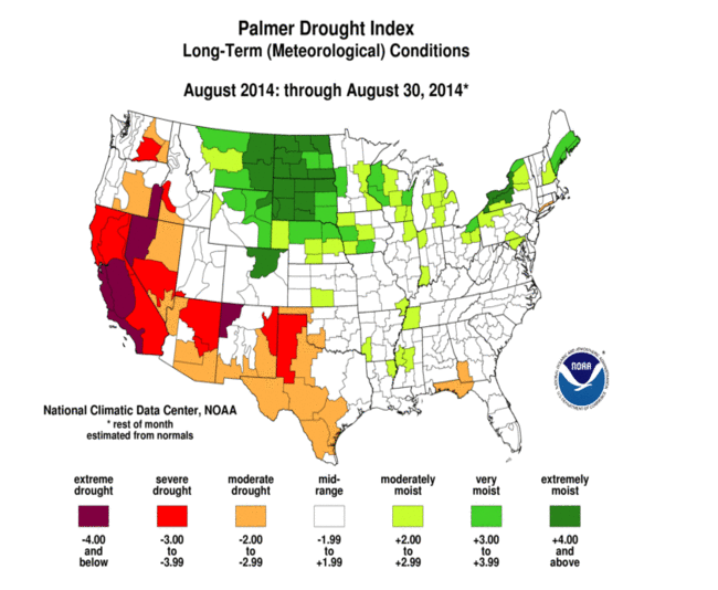
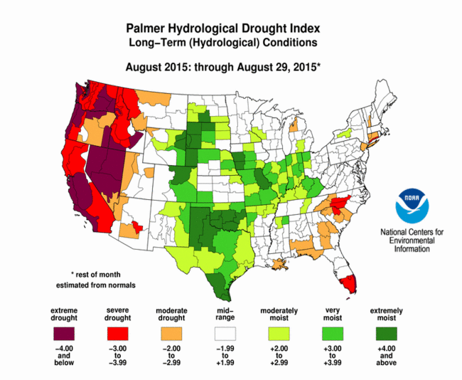
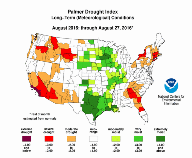
Article editor: Dr. Dagomar Degroot, Georgetown University 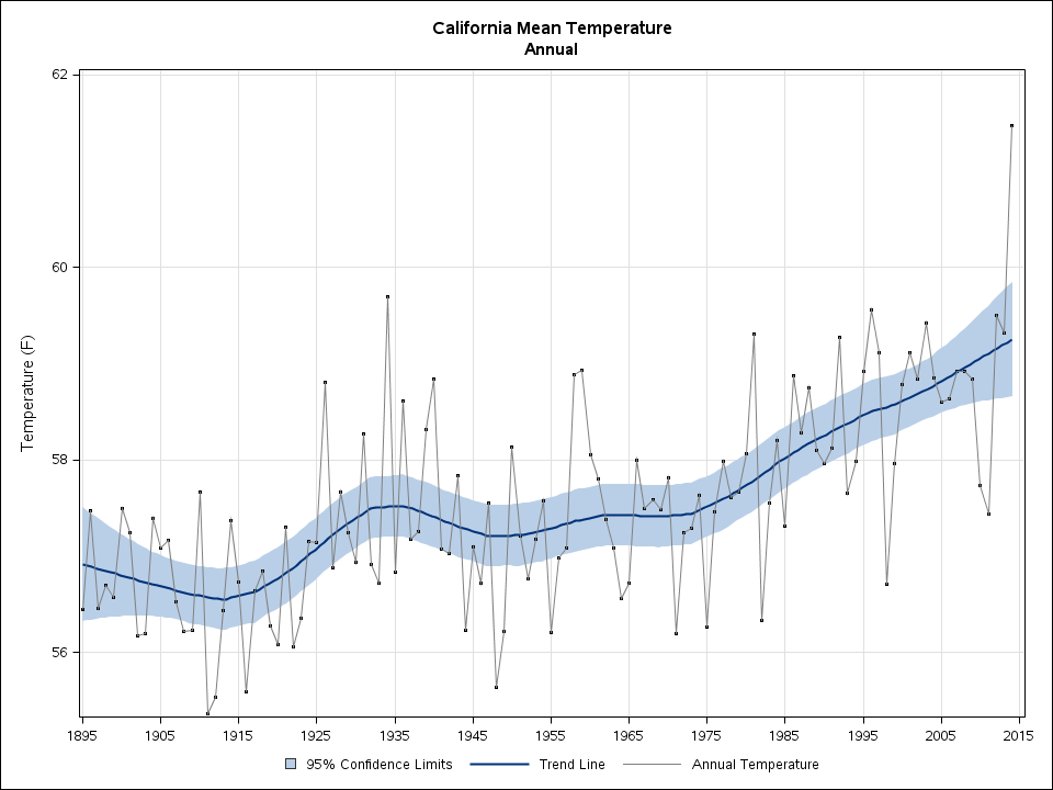 Mean annual temperatures in California since 1895. Source: NOAA State Annual and Seasonal Time Series. Climate changes and the local environment:Average annual temperatures across California have been rising since the nineteenth century, a trend that has sharply accelerated since around 1970. Average temperatures across all seasons in Tulare County in south central California have mirrored that statewide pattern. As the county warmed, it suffered a series of severe droughts, which are usually defined as long-lasting moisture deficits that have environmental and social consequences. Droughts in the county involve three sources of water: surface water at low elevations, snow at high elevations, and groundwater buried below the surface. Precipitation in much of California has long varied by as much as 50% from year to year. Hotter temperatures, however, are increasing the rate of evaporation across California, including in Tulare County. That has affected both mountain snow and lowland liquid water, and has made local droughts even longer and drier than they once were. One of the most severe droughts in the county's history recently began in 2014 and lasted until early 2017. It was part of a broader Californian drought that started in coastal areas several years earlier, and was up to 27% more likely to occur in our warmer climate. 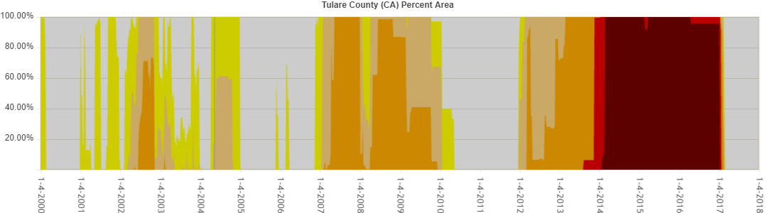 Drought severity in Tulare from 2000 until 2017, showing the landmark drought of 2014-2017. Darker colors represent worse droughts; higher values mean more of the county was in drought. Source: United States Drought Monitor. How we know:These reconstructions rely on several easy to use tools that are available online: the National Oceanic and Atmospheric Administration (NOAA) State Annual and Seasonal Time Series, the NOAA Weekly Palmer Drought Indices, and the National Drought Mitigation Center's United States Drought Monitor. NOAA's State Annual and Seasonal Time Series relies largely on weather station measurements. NOAA's Palmer Drought Indices use a standard way of measuring drought that considers both water supply and demand in a soil moisture model. Negative values represent droughts, and positive values represent wet conditions. The United States Drought Monitor uses a number of drought indicators, including the Palmer Drought Indices, that consider both environmental and social manifestations of water shortages. The above reconstructions also draw on an important study in Geophysical Research Letters, which estimates the possible contribution of global warming to the 2012-2014 drought in California. Human consequences:Severe droughts since the 1970s have badly hurt Californian farmers. In 2015 alone, farmers could not grow crops on nearly 500,000 acres of farmland, which accounted for a large share of the drought's annual economic cost to the state of nearly $3 billion. Tulare county was among the hardest-hit communities. The county has been one of the most productive agricultural counties in the United States. Its economy depends on the dairy industry, as well as crops such as oranges and grapes, which all require abundant water. Not only did these industries suffer particular hardships during the drought, but the drought also lasted longer in Tulare than it did in most other Californian counties. In 2014, the Tulare county Board of Supervisors declared a state of emergency and requested water transfers into the county from other parts of California. Yet hundreds of local wells remained dry into 2017. Many of the county's farms resorted to over-exploiting groundwater that may never fully recover, leaving them more vulnerable to future droughts that a changing climate will make longer and drier. While the recent drought has now ended, it may have long-lasting consequences for local agriculture. Further reading:
Article author: Dr. Dagomar Degroot, Georgetown University
|
 RSS Feed