Climate changes and the local environment: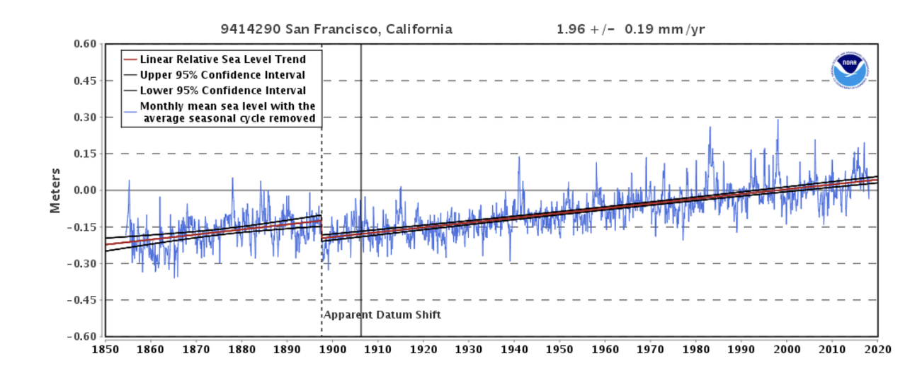 Changes in sea level in San Francisco, California, from 1850 through today. Source: NOAA Tides and Currents. Over the past century, Marin County has experienced eight inches of sea level rise, and by 2100 could ultimately see an increase of 16.6 to 65.8 inches. Global sea level rise, prompted by increased concentrations of atmospheric greenhouse gases such as carbon dioxide, can be attributed to two main factors: Arctic ice caps are melting, and oceans are warming thus expanding in volume. The most extreme emission scenario, which represents the worst possible future scenario, projects a 4ºC increase in temperatures and a global sea level rise of 8.9 meters. If current global emissions are restricted and warming is limited to 1.5ºC, global sea levels are still projected to rise by 2.9 meters. Marin County’s location on the coast of California makes it highly susceptible to the impacts of global sea level rise. The projected increase in sea levels will threaten beaches and wetlands, introduce salt water to inland areas, and displace native coastal organisms. In Marin County, 13,774 acres of land have already been declared vulnerable to the threats of sea level rise. 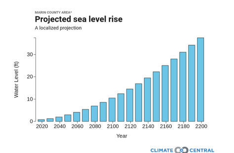 Projected sea level rise in Marin County based on extreme emission scenarios from NOAA. Source: Climate Central Risk Finder. 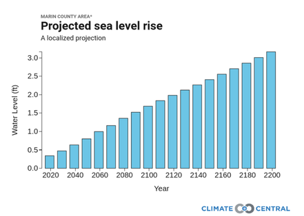 Projected sea level rise in Marin County based on intermediate-low emission scenarios from NOAA. Source: Climate Central Risk Finder. Rising sea levels will increase the frequency and intensity of flooding, and the damages will be worsened due to large coastal storms. These storms will also become more severe, as the warming atmosphere is capable of holding more moisture. California is especially prone to infrequent, intense rain events, and often receives the majority of its annual precipitation in only one or two large storms. Sea level rise, combined with more intense storms and floods, will fundamentally alter Marin County’s environment by accelerating erosion, introducing saltwater to inland environments, and drastically altering coastal species’ habitats. In some cases, rising tides will make a portion of the County disappear completely. 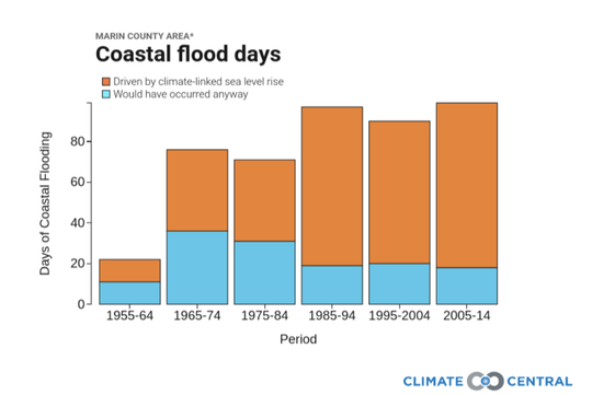 Reconstructions of the percentage of coastal flooding days that can be attributed to climate-linked sea level rise and to unrelated forces from 1950 to the present. Source: Climate Central Risk Finder. How we know:These projections and reconstructions are based on freely accessible online tools from The National Oceanic and Atmospheric Administration (NOAA) Tides and Currents tool and the Climate Central Surging Seas: Risk Finder projections and tools. The NOAA Tides and Currents resource reports local mean sea level changes from 1850 to today. It uses data collected from U.S. and global water level stations to reconstruct local sea level trends. The Climate Central Surging Seas tool generates sea level projections based on the different emissions scenarios presented in the NOAA Technical Reports. This tool uses data from the San Francisco water level station to generate the coastal flood days graph. Human consequences:Rising sea levels and worsening floods will pose health threats to the residents of Marin County and may require citizens to relocate. Furthermore, it is likely these factors will compromise the County’s water quality. Occasionally, increased flooding could improve water quality due to water percolation through the soil; however, prolonged flooding more often stresses or over floods the soil, ultimately degrading water quality. With more frequent floods, salt water, excess nutrients from fertilizers, and sediment from erosion are expected to enter the groundwater in Marin County. In addition, the current storm water drainage will not be suited to handle more severe storms, causing flooding in the streets. This will also threaten human health, as it increases the risk that sewage systems will overflow and contaminate groundwater. Rising sea levels will also affect the properties in Marin County that are currently on the coast. In a lower emissions scenario projecting three feet of sea level rise, $4.2 billion worth of properties will be compromised. In an extreme emission scenario that forecasts 10 feet of sea level rise, property damages will reach nearly $9.3 billion. In 2016, the Public Policy Institute of California reported that one in five Californians lives in flood-prone areas. The costs to replace this vulnerable infrastructure could exceed $575 billion, as an increasing number of buildings will be in high-risk zones. As the effects of sea level rise and severe floods worsen in Marin County, residents and the local government must take steps to reduce current damages and to minimize future impacts. In response to increased flooding, Marin County has already widened creeks to reduce erosion, support higher water levels during floods, and restore wetlands. To combat sea level rise, Marin County has implemented structural defenses, such as floodwalls, levees, and tidal gates. Additionally, as the County recognizes that many future impacts cannot be mitigated, it promotes adaptive measures such as building elevated structures, relocation of at risk infrastructure, and planned retreats. The County’s website also includes an extensive action plan detailing flood prevention procedures and emergency protocols. As the impacts of severe floods and rising sea levels intensify, Marin County must continue to promote methods to mitigate and adapt to these changes. Further reading:California's Water. Public Policy Institute of California Flood Protection. Marin Watersheds Sea Level Rise. Marin Watersheds Article author: Esther Doerr, Georgetown University
Article editor: Maddie Bowen, Georgetown University
2 Comments
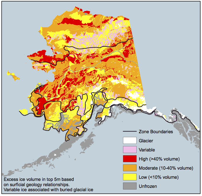 Ice cover across Alaska in 2008. Source: University of Alaska Permafrost Laboratory. Climate changes and the local environment: Alaska is warming more than twice as quickly as the contiguous United States. Over the past 60 years, average annual temperatures in Alaska have increased by about 3°F. Winter warming has been even more extreme, with average seasonal temperatures rising by 6°F. Climate projections based on continuing high greenhouse gas emissions - known as "high emissions scenarios" - predict that average winter temperatures in towns across North Slope Borough in northern Alaska will rise by as much as 25°F in the coming century. By 2050, average annual temperatures across Alaska are expected to increase by 2 to 4°F. As Alaska continues to warm, melting sea ice and coastal erosion represent the two most pressing threats to North Slope Borough. Permafrost is a thick layer of soil, usually a foot or so down from the surface, that remains frozen year-round. Permafrost covers over 80% of Alaska, but that number is shrinking as rising temperatures cause permafrost to melt. When permafrost melts, the ground above it collapses, and methane enters the atmosphere. Methane is a potent greenhouse gas, and although it does not stay in the atmosphere for long when compared to carbon dioxide, it can cause profound regional warming. Thus because melting permafrost also increases atmospheric methane, rising temperatures will provoke even more warming and melting. Increasing temperatures will also melt sea ice on the coasts of Alaska. Models that match historical trends predict that, by 2030, the entire Arctic could be ice-free in the summer. Loss of sea ice is dangerous for ecosystems in North Slope Borough. In the colder past, sea ice acted as a natural barrier to storms and waves. However, as the sea ice melts and recedes from the coastline, wind and water erosion is projected to increase accordingly, especially during big storms. Permafrost also once protected the North Slope Borough coasts from erosion, but it may not for much longer. 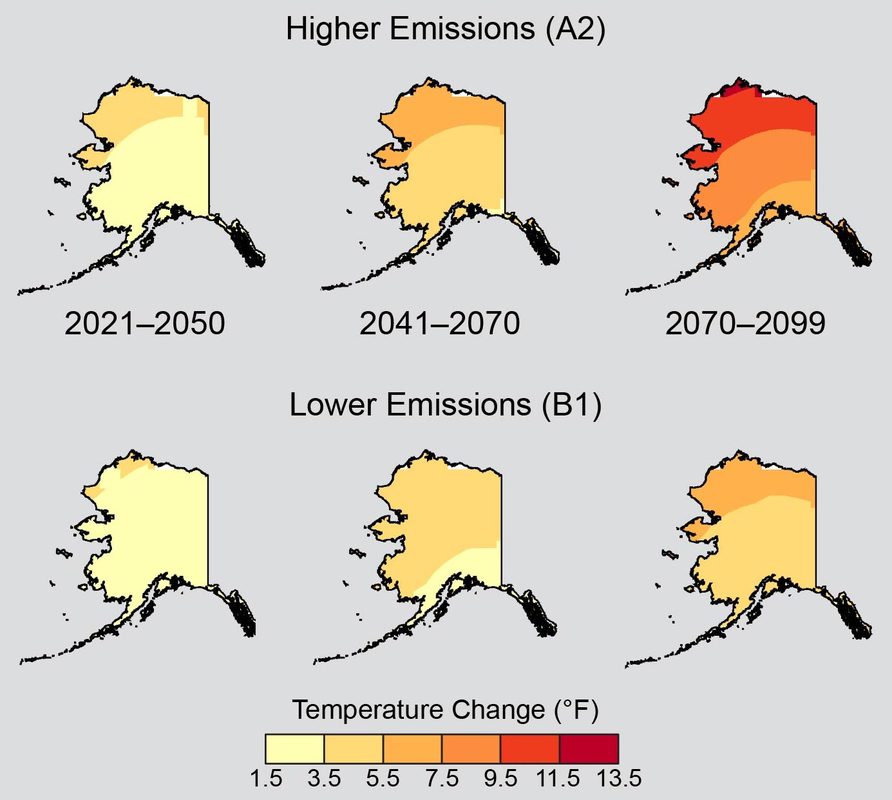 Average annual temperatures will increase across Alaska under all emissions scenarios. Warming will be especially rapid in Northern Alaska, including North Slope Borough. Source :U.S. Global Change Research Program. How we know: These predictions are largely based on two easy-to-use tools that are freely accessible online: the National Aeronautics and Space Administration’s (NASA) GISS Surface Temperature Analysis and the National Snow and Ice Data Center’s Arctic Sea Ice News and Analysis (NSIDC). The GISS Surface Temperature Analysis tool uses maps to show global temperature anomalies, comparing current temperatures to temperatures in the 1951-1980 period. Mean temperatures are averaged over a specific time period and interval, and the analysis is updated monthly. Data is compiled from the National Oceanic and Atmospheric Administration’s databases and satellites. The Arctic Sea Ice News and Analysis tool provides updates and scientific analysis on the conditions of Arctic sea ice. The website publishes graphs and animated visuals documenting the extent, depth, and concentration of sea ice. The tool is run by National Snow and Ice Data Center scientists, along with support from NASA. Human consequences: Future climate change will likely have devastating consequences for North Slope Borough and its residents. The imminent reality of a seasonally ice-free Arctic may sound like a desirable outcome at first, seeing that some economic opportunities such as faster shipping routes, oil and gas exploration, and tourism may become available. However, coastal villages, which represent many of the residences in North Slope Borough, will face one of two unfortunate realities as erosion threatens homes. At best, residents will be forced to relocate inland, and at worst, homes and even lives will be lost to the sea. More than 30 villages in North Slope Borough have already been identified for relocation. Indigenous lives are especially threatened as climate change continues in the coming century. Alaskan Iñupiat make up fifty-two percent of all residents in North Slope Borough, according to a 2016 census. Many rely on a subsistence diet and are therefore relatively vulnerable to sudden changes in their surrounding ecosystems. Whales and seals, which are hunted out on the sea ice, constitute the majority of the protein in local Iñupiat diets. With the sea ice retreating, the accessible supplies of fish, game, and whales will decline, and Iñupiat hunters will have to brave dangerously thin ice in hopes of catching food. Thawing permafrost may also undermine human health and economic growth in North Slope Borough. These problems will include a loss of clean water, saltwater intrusion, and the expansion of diseases northward into the warming climate. Many villages, especially those of lower income, dig holes into the permafrost and use these to dispose of and contain sewage; however, as the permafrost thaws, the sewage will leak out, resulting in contamination and the spread of disease. Thawing permafrost will also contribute to increasing pollutant exposure to residents, as the soil contains a significant amount of mercury and carbon dioxide. Additionally, thawing permafrost is projected to add up to $6.1 billion in maintenance costs, as the uneven sinking of the ground will disrupt existing infrastructure. Unfortunately, many of these events will occur even if warming is slowed by curbing emissions. Combating these changes will require both adaptation and resilience in North Slope Borough and beyond. Further reading: Alaska Regional Climate Projections. Scenarios Network for Alaska Planning. Alaska. U.S. Global Change Research Program Article author: Georgia Brainard, Georgetown University
Article editor: Dr. Dagomar Degroot, Georgetown University |
 RSS Feed