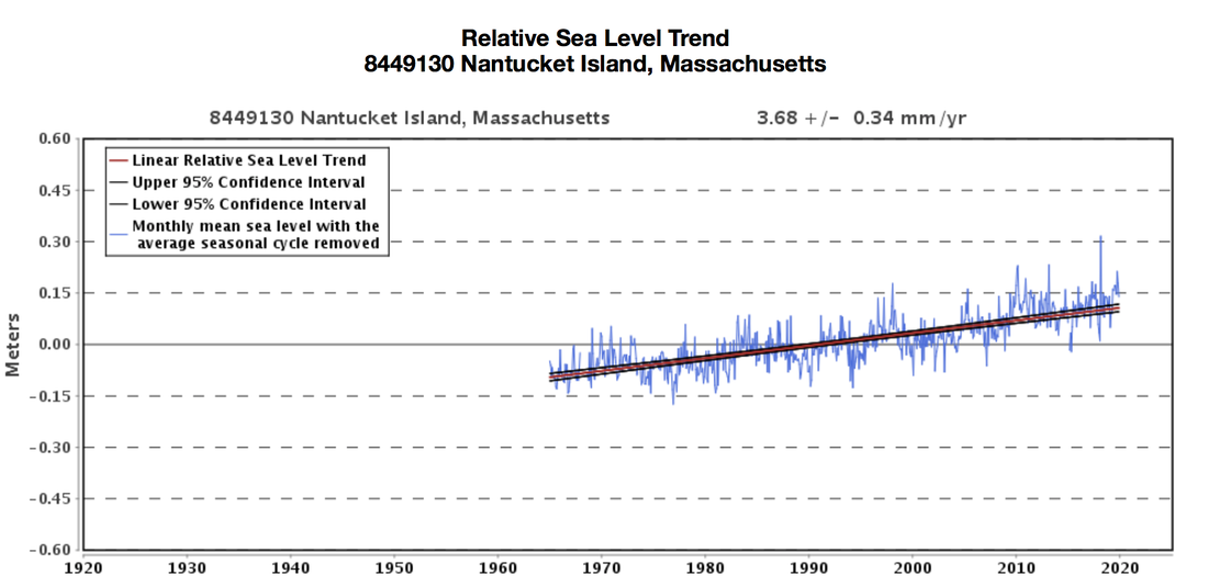
 Changes in sea level in Nantucket County, Massachusetts from 1965 through today. Source: NOAA Tides and Currents. Climate changes and the local environment:As the amount of greenhouse gases in the atmosphere continues to increase, the average global temperature will increase as well. With an intermediate-low emission scenario, it is predicted that we could see an increase of 2 ̊C by 2100. Under the most extreme emissions scenario, average annual temperatures could rise by up to 4 ̊C in the coming century. Both emissions scenarios – either a 2 ̊C or 4 ̊C increase – will lead to global sea level rise. This increase in sea levels has two direct causes. First, thermal expansion of the world’s oceans occurs as average global temperatures, and thus oceanic temperatures, rise. This leads to an increase in kinetic energy of the water. This increase in molecular movement then causes an expansion in the water’s volume. Second, rising temperatures will speed up the melting of ice caps in Greenland and Antarctica. This melting will add more water to the Earth’s oceans and raise sea levels. Nantucket Island will continue to face extreme regional impacts as sea levels continue to rise. Given its location as an island off the coast of Massachusetts, Nantucket is especially susceptible to the effects of rising sea levels. If global temperatures increase by 2°C, Nantucket could see up to 10 feet of sea level rise. If temperatures increase by 4°C, oceans surrounding the County could rise by as much as 19 feet. In both emissions scenarios, all of historic Nantucket - a community hundreds of years old - would be underwater; however, with a rise in sea levels of 19 feet, a significant portion of the island could become submerged. 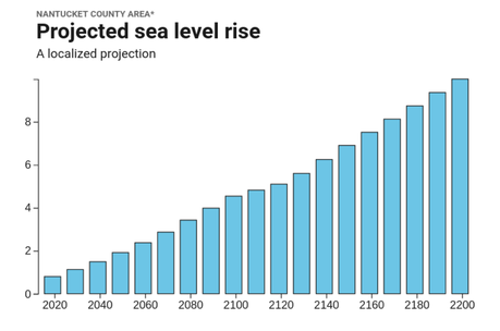 Projected sea level rise in Nantucket County under an intermediate-low emissions scenario. Source: Surging Seas Risk Finder. 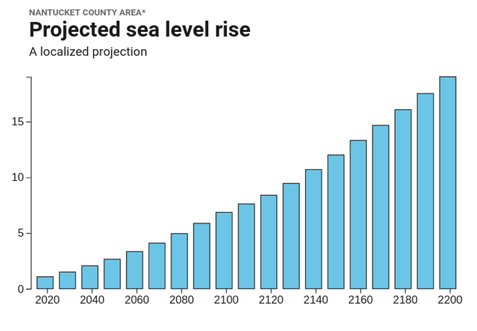 Projected sea level rise in Nantucket County under a high emissions scenario. Source: Surging Seas Risk Finder. The impacts of rising sea levels in Nantucket County will be intensified by coastal erosion. Nantucket is already losing coastal land at alarming rates due to the weathering of shorelines, a phenomenon exacerbated by potentially worsening hurricanes. Additionally, Nantucket County is an island composed of compacted sand, only making it more susceptible to coastal erosion. Portions of the island’s shorelines have already lost more than one hundred feet of coast depth in just the past decade. As global temperatures continue to rise, it will not just cause much of Nantucket to be below sea level, it will also speed up the erosion process until the island itself could cease to exist. How we know:These projections primarily rely on the free and easily accessible Tides and Currents tool by The National Oceanic Atmospheric Administration (NOAA) and Climate Central’s Surging Seas: Risk Finder projections. NOAA’s Tides and Currents resource uses data collected from over 140 long-term water level stations to reconstruct local relative sea level trends. These measurements are averaged monthly in order to present an accurate linear sea level trend. Climate Central’s Surging Seas: Risk Finder generates projections for sea level rise, as well as flood risks, based on the different emissions scenarios in the NOAA Technical Reports. This tool generates the projections for Nantucket County using data from the Nantucket sound water level station, located 2 miles from central Nantucket. Human consequences:The year-round population in Nantucket County is approximately 12,000 individuals; however, due to tourism, the population swells to 60,000 during the summer months. The County has more than 800 buildings and structures which were built before the Civil War and are historically preserved through the island’s local governance. The majority of these preserved buildings were built around Nantucket Harbor, the historic hub of the island’s once-famous whaling industry. It is this harbor, along with the surrounding historic buildings, that will likely be submerged underwater, with even a 2°C global temperature increase, if decisive actions are not taken. Additionally, the majority of the County’s prime real estate is located along the coast. Under a low emissions scenario, the total value of homes in Nantucket at risk of rising sea levels and increased floods could reach $990,000,000 by 2050. As a result of the severe erosion that Nantucket has already experienced, many of the island’s most valuable properties and historic landmarks - including some of the United States’ oldest lighthouses - have had to undergo relocation. Moving these properties to inland sites will temporarily protect the structures, but this process has cost residents on the island millions of dollars and, if sea levels continue to rise, will result in future costs for decades to come. The most recent and effective, yet expensive, solution to this problem is the installation of geotubes. Geotubes are two hundred feet long, seven-and-a-half feet tall, and 20 feet wide. Stacked four high, they line the island’s beaches where erosion is most severe. While designed to withstand the force of the nonstop waves and stay firmly in place, the geotubes are covered with additional sand to make the engineered bluff look as natural as possible. Geotube sand coverage also contributes sand to the natural erosion process without risking further destruction of the island’s beaches. Ultimately, Nantucket County’s fate depends greatly on how quickly and effectively measures can be taken to combat rising global temperatures and sea level rise. If emissions continue at the current rate, Nantucket Island will likely cease to exist and with it, the highly lucrative tourism industry and centuries of history. Further reading:Nantucket's Bluffs and Beaches are Crumbling in the Face of Storms and Rising Seas. PRI Chronicle: Fighting Erosion on Nantucket. WCVB More Details on Geotubes. Siasconset Beach Preservation Fund Article author: Benny Weisman, Georgetown University
Article editor: Maddie Bowen, Georgetown University
2 Comments
Im bored
4/5/2021 02:02:15 pm
kk Leave a Reply. |
 RSS Feed