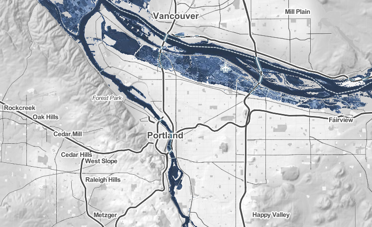
 Projected sea level increases in Multnomah County given 2.5° C warming, relative to twentieth-century averages. Source: Climate Central. Climate changes and the local environment: A 2013 report from the Intergovernmental Panel on Climate Change layed out the specific ways in which global warming has changed, and will continue to shape, the planet’s many environmental systems. For Multnomah County, this means increasing average temperatures throughout the year, greater incidence of extreme heat days, and increased risk of flooding. Multnomah County, home to the city of Portland, rests on the bank of the Willamette River. Even with conservative estimates of climate change and a global increase of only 1 degree Celsius, Portland would experience significant flooding of up to seven feet. With a global temperature increase of 2 degrees Celsius, the Limit set by The Paris Agreement on Climate, Portland would see fifteen feet of flooding. Multnomah’s average temperatures are also predicted to increase, and have been increasing notably since the mid 1950s according to the chart from the National Oceanic and Atmospheric Alliance, and is predicted to rise at increasing rates for the next century. Even in the “low emissions” scenario, average temperature in Multnomah County is predicted to increase by about 4 degrees Farenheit in the next century, or up to 9 degrees Farenheit in the high emissions scenario. While Oregon as a whole has a highly variable climate, Multnomah county is a fairly consistent climate zone, ranging from a 40° F average in January to a 68° average in July. However, extreme heat days are predicted to quadruple in frequency from about ten a year in 2000 to 40 a year by 2050. This will have major sociological and economic implications for the county. 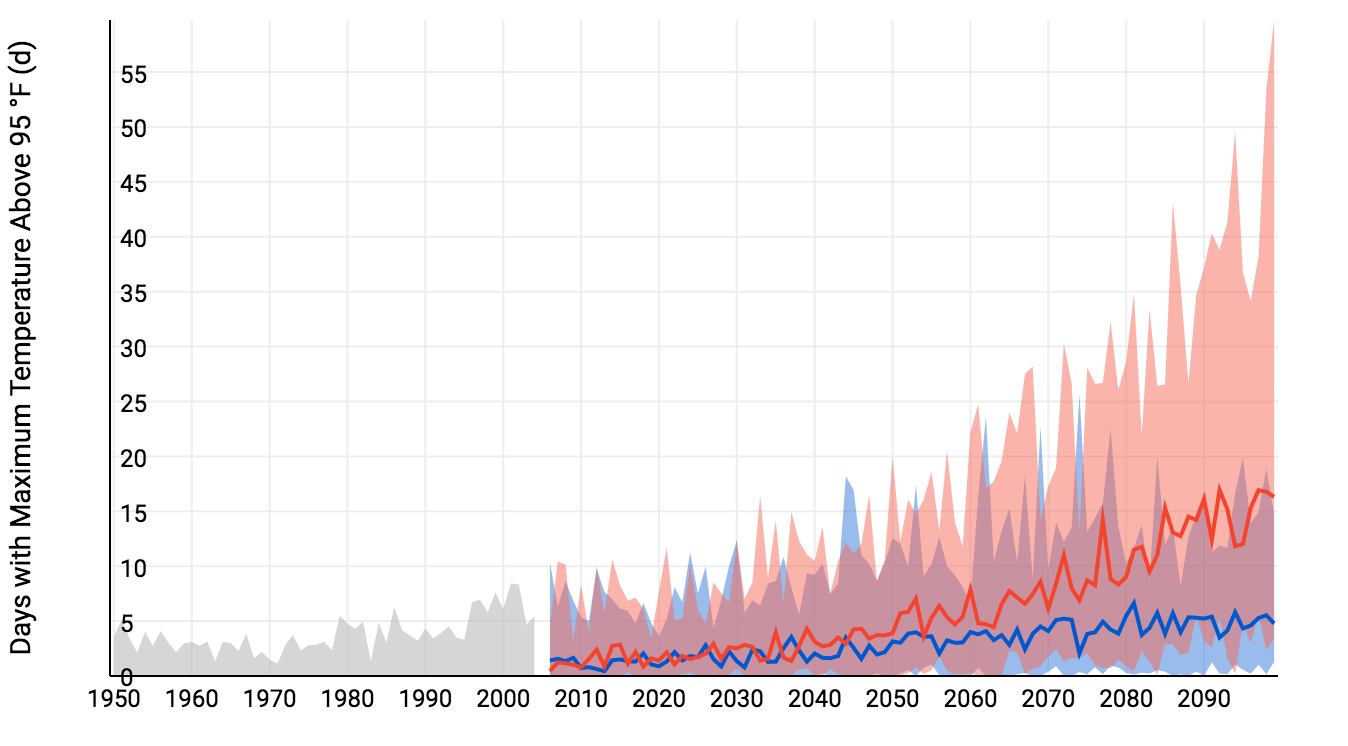 Mean daily maximum temperature for Multnomah County in the past (grey) and the projected future under high (red) and low (blue) emissions scenarios. Source: NOAA Climate Explorer. How we know: These projections primarily rely on two tools that are freely accessible online: the National Oceanic and Atmospheric Administration (NOAA) Climate Explorer app, and the Climate Central Surging Seas, Mapping Choices app. The Climate Explorer tool uses weather information recorded by meteorological instruments at weather stations to reconstruct past climate changes. It uses supercomputer simulations of future climate changes under both high and low emissions scenarios. The Surging Seas tool combines historic flood statistics and local sea level trends with global scenarios of sea level increases, which were compiled in the 2014 U.S. National Climate Assessment. Data from simulations like these is then combined with studies of local economy, current local policy, and state infrastructure to create resources like America’s Preparedness Report Card from Climate Central and ICF International. This resource synthesizes climate and sociological data and grades each state on its level of preparedness for each of five future climatological hazards related to climate change. 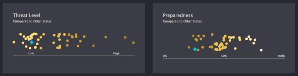 Severe heat day risk and preparedness in Oregon relative to the other 50 states. Source: America’s Preparedness Report Card. Human consequences: In America’s Preparedness Report Card, Oregon as a whole received an “F” in Extreme Heat preparedness. Though extreme heat is not currently a major risk to the state, the projected increase of extreme heat days and Oregon’s lack of policy or public health plans designed to deal with that increase leaves Oregon, and Multnomah County, in a risky position. Extreme heat disproportionately harms vulnerable populations like the elderly, young children, and people experiencing homelessness. Without proper planning, Multnomah is unprepared for the public health costs and risks to its citizens that an increase in extreme heat days will bring. The increased frequency of wildfires and decreased air quality overall in the city of Portland already affects Multnomah county residents, and is predicted to worsen in coming decades, leaving asthma sufferers and others with compromised respiratory systems at particular risk for life threatening health complications. On a more general level, the Willamette Valley, including Multnomah County, is the most diverse agricultural area of the state, and is, therefore, reliant on predictable and consistent climatological and weather patterns to maintain this industry sector. Agriculture and recreation are major sectors of the Oregon economy, and even more so for Multnomah County at the intersection of agriculture and tourism from Portland. Therefore, damage from climate change—droughts and subsequent crop failures, urban space loss, and resident migrations—would be a major financial burden to the area. When surveyed, residents of Multnomah county have a higher than average awareness of climate issues, as well as higher than average concern over the impact of climatological effects. However, despite local governmental and community adaptations made to address the changing climate, a few key oversights leave Multnomah County vulnerable to the public health and infrastructural risks of climate change. Further reading: Article author: Madelyn Rice, Georgetown University
Article editor: Dr. Dagomar Degroot, Georgetown University
1 Comment
Lindsey
3/4/2021 02:24:02 am
I am shocked to hear that an increase of just two degrees would cause 15 feet of flooding in Portland. What are some changes that Oregon could implement to increase their Extreme Heat Preparedness and to limit their vulnerability to the risks of climate change? The public health risks associated with climate change are a huge issue. Heat is a huge threat to people experiencing homelessness as you mentioned. These people are also more vulnerable to floods and other natural disasters associated with climate change. Leave a Reply. |
 RSS Feed