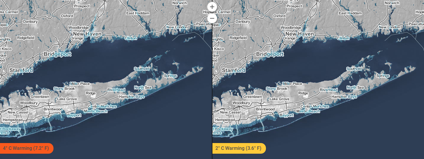
 Changes to the Suffolk County coastline under two different emissions scenarios. Source: Climate Central Surging Seas: Mapping Choices. Climate changes and the local environment:As global sea levels rise, regional variations in ocean temperatures, prevailing winds, ocean currents, and the rise or fall of Earth's crust mean that some communities have experienced, and will experience, greater sea level increases than others. Sea levels off Suffolk County, Long Island, for example, are rising at a rate of around 3.23 mm/year, which is up from 2.78 mm/year just one decade ago. New York State is in fact sinking relative to the sea, owing to a combination of human activity and the slow rebound of the landscape following the retreat of the great glaciers that covered the state during the last ice age. Meanwhile, the melting of polar ice sheets and the warming of Earth's oceans mean that seal levels off the state are projected to increase steadily. If emissions of greenhouse gases continue unabated, and average global temperatures rise by around 4° C (roughly 7° F) relative to twentieth-century averages, then the entire southern coast of Long Island, including that of Suffolk County, will eventually be inundated. Montauk, the tip of Suffolk County, will then become its own island, separated from Long Island by a chasm of water. Winters, meanwhile, are expected to grow shorter but wetter, and major storms - such as Superstorm Sandy - are projected to grow more common. Storm surges will likely threaten natural defenses against the sea, including saltwater marshes and dunes, in ways that may permit even more extensive flooding. 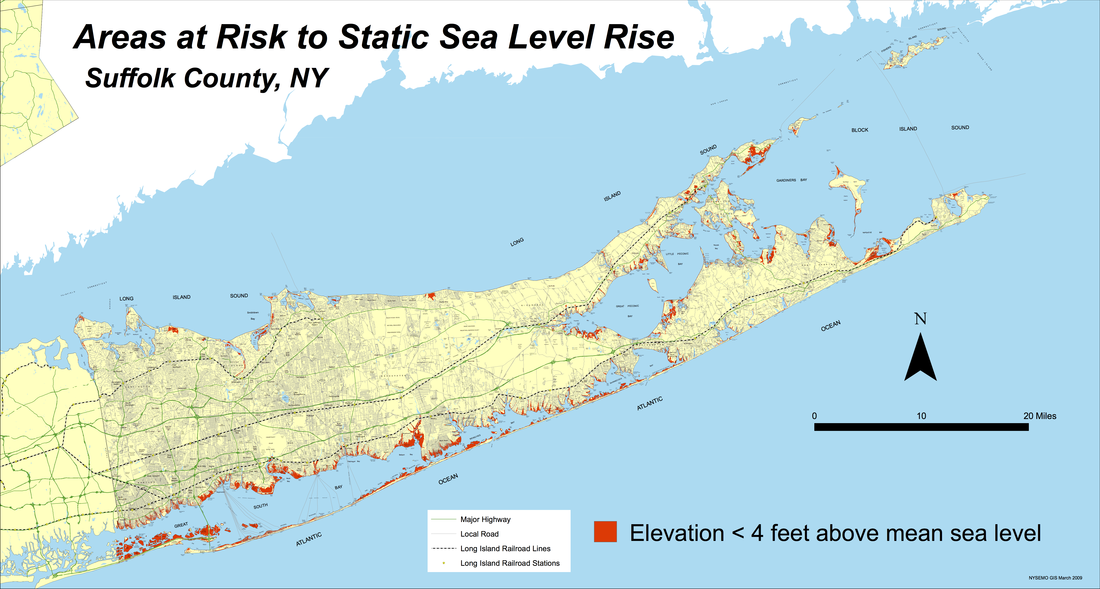 Areas in red are less than four feet above sea level, and are already highly vulnerable to flooding in major storms. Source: Department of Environmental Conservation, New York State. How we know:These projections and reconstructions are largely based on reliable, easy to use tools that are freely accessible online: the National Oceanic and Atmospheric Administration (NOAA) Sea Level Trends app, the NOAA Climate Explorer app, and the Climate Central Surging Seas, Mapping Choices app. The Sea Level Trends tool shows regional mean sea level changes from the twentieth century through today. NOAA collects data for these measurements through the 142 long-term tide stations of the National Water Level Observation Network, which has been measuring sea level for over 150 years. Each regional mean sea level rise or fall is computed using a minimum of 30 years of data to ensure accuracy. The Climate Explorer tool uses weather information recorded by meteorological instruments at weather stations to reconstruct past climate changes. It uses supercomputer simulations of future climate changes under both high and low emissions scenarios. The Surging Seas tool combines historic flood statistics and local sea level trends with global scenarios of sea level increases, which were compiled in the 2014 U.S. National Climate Assessment. These projections also make use of a map designed by the New York State Department of Environmental Conservation, which shows the extent of low-lying coastal areas around Suffolk County. 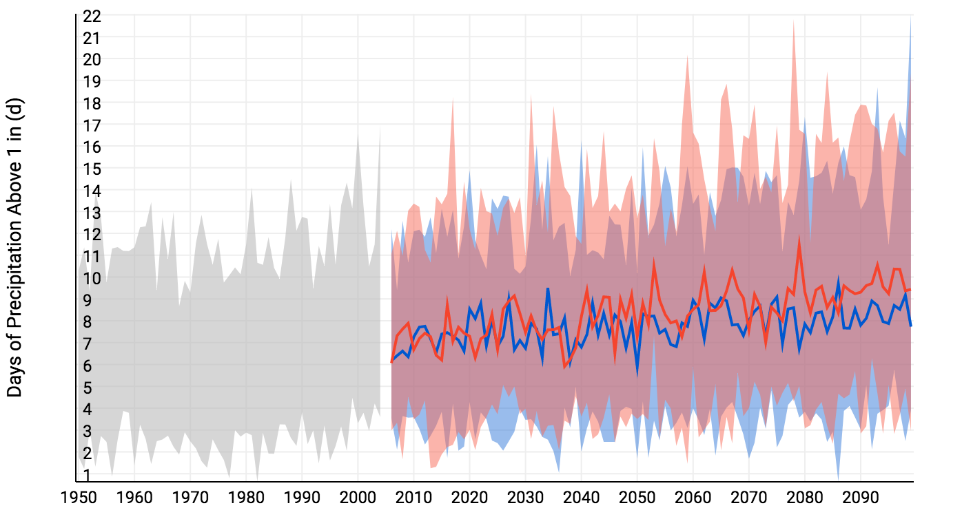 Modeled days of extreme precipitation in Suffolk County, up to 2100. Much of the projected increase involves winter precipitation. Red shows the projection for a future with higher emissions, and blue with lower emissions. Source: NOAA U.S. Climate Resilience Toolkit (Climate Explorer). New York State is the third largest coastal flooding threat in the United States, and in 2008 it was reported that about 13.9 percent of the state's residents live directly on the coast. Many towns in Suffolk, particularly some of those located on the southern border, are precariously close to the sea. Even in scenarios that assume drastic action to curb human-caused greenhouse gas emissions, many of these towns will be underwater. Well before that happens, rising sea levels and intensifying storms will batter coastal infrastructure. Today, warming sea surface temperatures are already undermining the quality of local drinking water, and the health of coastal ecosystems, by creating ideal conditions for toxic bacteria. Wetlands that help filter pollution from water flowing out to sea, meanwhile, are vulnerable to rising sea levels and intensifying storms. Further inland, rising temperatures will encourage the spread of pollen, ragweed, and poison ivy, will creating more favorable conditions for Lyme disease. Suffolk County, in short, is set to become a far less healthy place for its inhabitants and the ecosystems on which they depend. In response, municipal, state, and federal governments have mobilized to shore up flood defenses - such as coastal dunes - while some county residents have elevated their coastal homes and businesses. In the long run, however, coastal areas of the county will either need to be protected using very expensive defenses against the sea, or evacuated to make way for the rising waters. Read more:Climate Change Could Threaten Long Island. The Weather Channel Coastline Population Trends in the United States: 1960 to 2008. US Census Bureau Article author: Isabel Paret, Georgetown University
Article editor: Dr. Dagomar Degroot, Georgetown University
0 Comments
Leave a Reply. |
 RSS Feed