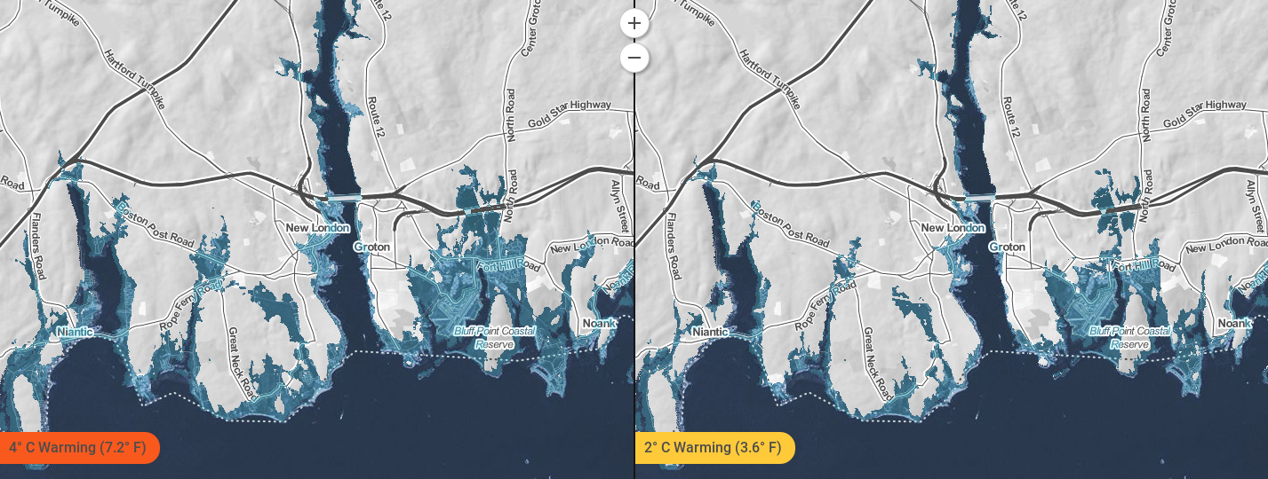
 Changes to the New London County coastline under two different emissions scenarios. Source: Climate Central Surging Seas: Mapping Choices. Climate changes and the local environment:Mean global sea levels have risen by at least 17 centimeters (nearly 7 inches) in the twentieth century. Yet regional variations in ocean temperatures, prevailing winds, ocean currents, and the rise or fall of Earth's crust mean some areas have experienced, and will experience, greater sea level increases than others. Off Connecticut, for example, sea levels are today increasing more quickly than the global average. Connecticut is in fact sinking as its crust slowly recovers from the immense weight of glaciers that covered it during the last ice age. Connecticut is sinking by over 0.03 inches per year, even as Earth's ocean rise. Rising sea levels and sinking land will have dire consequences for the environment of New London County in Connecticut. Low-lying coastal lands in and around the county will eventually be inundated, overwhelming natural flood and storm barriers such as beaches and wetlands. That will make the county ever more vulnerable to coastal storms and flooding, which will grow more frequent and severe as Earth's climate warms. In fact, the Connecticut Governor’s report predicts that by 2050, New London County may face a 100-year storm every 56 years. A 100-year storm refers to a storm of such rarity and magnitude that it has only a 0.1 percent chance of happening in New London County in any given year. Meanwhile, precipitation is on the rise in New London County as local temperatures warm. Hotter air holds more water vapor than cold air, so it is no surprise that average annual precipitation is increasing, while extreme precipitation events - such as torrential rains - are growing more frequent. Both trends are expected to accelerate in the future. Stronger storms sweeping in from the sea are therefore projected to bring more coastal floods in the warmer future, while heavier rains lead to more river floods in New London County. 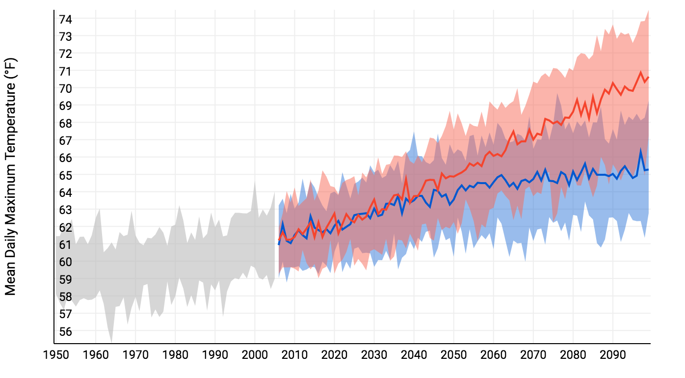 Past and projected changes to the daily high in New London County. Red shows the projection for a future with higher emissions, and blue with lower emissions. Source: NOAA U.S. Climate Resilience Toolkit (Climate Explorer). How we know:These predictions are based on four easy to use tools that are freely accessible online: National Oceanic and Atmospheric Administration (NOAA) Sea Level Trends app, the NOAA Climate Explorer app, and the Climate Central Surging Seas, Mapping Choices app, and the Aqueduct Global Flood Analyzer. The Sea Level Trends tool shows regional mean sea level changes from the twentieth century through today. NOAA collects data for these measurements through the 142 long-term tide stations of the National Water Level Observation Network, which has been measuring sea level for over 150 years. Each regional mean sea level rise or fall is computed using a minimum of 30 years of data to ensure accuracy. The Climate Explorer tool uses weather information recorded by meteorological instruments at weather stations to reconstruct past climate changes. It uses supercomputer simulations of future climate changes under both high and low emissions scenarios. The Surging Seas tool combines historic flood statistics and local sea level trends with global scenarios of sea level increases, which were compiled in the 2014 U.S. National Climate Assessment. The Global Flood Analyzer estimates the vulnerability of regions to flooding, providing figures for the cost of flood damage and number of people affected. 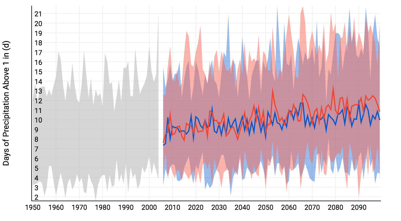 Past and projected days, per year, with more than one inch of precipitation in New London County. Red shows the projection for a future with higher emissions, and blue with lower emissions. Source: NOAA U.S. Climate Resilience Toolkit (Climate Explorer). Human consequences:New London County is already coping with climate change. In 2010, New London endured a 100-year flood after heavy rains caused rivers to spill their banks and ground water to overflow sewage systems. The Federal Emergency Management Agency (FEMA) estimated that the flood cost the county $5.3 million in losses and damages. Precipitation trends will make such floods more common. In New London County, a total of 4,306 residents currently live in homes that are less than 6 feet above sea level. By 2030, there is a 67% chance that flood with waters 6 or more feet above sea level will occur, which would put all these lives and homes at risk. Increased intensity and frequency of both coastal storms and flooding is hugely detrimental to infrastructure and business in New London County. In particular, the Naval Submarine base and the General Dynamics Electric Boat Corporation submarine construction yard, which is the primary builder of submarines for the U.S. Navy, are at risk from sea level rise, storms, and flooding. These establishments are essential to the county’s economy and to national security. Re-engineering of the base and the submarine construction yard may be necessary in order to keep them functional in the face of rising sea levels, yet this would be staggeringly expensive. The consequences of climate change and global warming have already harmed many of coastal communities in New London County. Under all future emissions scenarios, even very optimistic ones, further damage is all but inevitable. Further reading:Climate Change Primer - Sea Level Rise and Coastal Storms. State of Connecticut Climate Suggests Floods will Probably Happen Again. The Day Article author: Georgia Brainard, Georgetown University
Article editor: Dr. Dagomar Degroot, Georgetown University
3 Comments
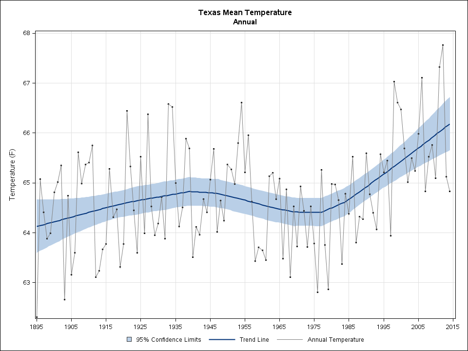 Mean annual temperatures in Texas since 1895. Source: NOAA State Annual and Seasonal Time Series. Climate changes and the local environment:For decades, global warming has increased sea levels in most coastal regions. Glacial meltwater has poured into the oceans, while warming water has expanded, taking up more volume and therefore sending sea levels ever higher. Communities at risk of major tropical cyclones - such as Galveston county, Texas - have faced the full consequences of these changes to the world's oceans. Hurricanes are fueled by warm, moist air rising from warm water. The warmer the water, the more fuel hurricanes can use. While global warming has likely not increased the frequency of hurricanes overall, it has increased the frequency of exceptionally severe storms. Currently, powerful hurricanes are up to 11% stronger and more dangerous for communities such as Galveston. A hurricane's winds usually cause the greatest damage to human infrastructure by pushing ashore enormous quantities of water. These "storm surges" are highest in powerful hurricanes, which means that they are more frequently destructive now than they have been. Off Texas, rising sea levels have made them even worse. Between 1957 and 2011, sea levels off Galveston rose by just over a foot, which has greatly increased the damage that will be inflicted to the county in a major hurricane. 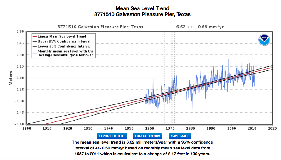 Sea levels off of Galveston, Texas, 1957-2011. Source: NOAA Tides and Currents. How we know:This information is derived from the National Oceanic and Atmospheric Administration (NOAA) study that connects global warming and hurricanes. It also draws from easy to use tools that are available online: the NOAA State Annual and Seasonal Time Series, and the NOAA Tides and Currents resource. NOAA’s GFDL study on Global Warming and Hurricanes pulls data from published articles regarding hurricane intensity and temperature fluctuations since the 1800s. NOAA’s State Annual and Seasonal Time Series is derived from the current U.S. Climate Division Database that pulls data from temperature stations. NOAA’s Tides and Currents produces sea level trends measured from U.S. and Global Stations without the regular seasonal fluctuations due to coastal ocean temperatures, salinities, winds, atmospheric pressures, and ocean currents. 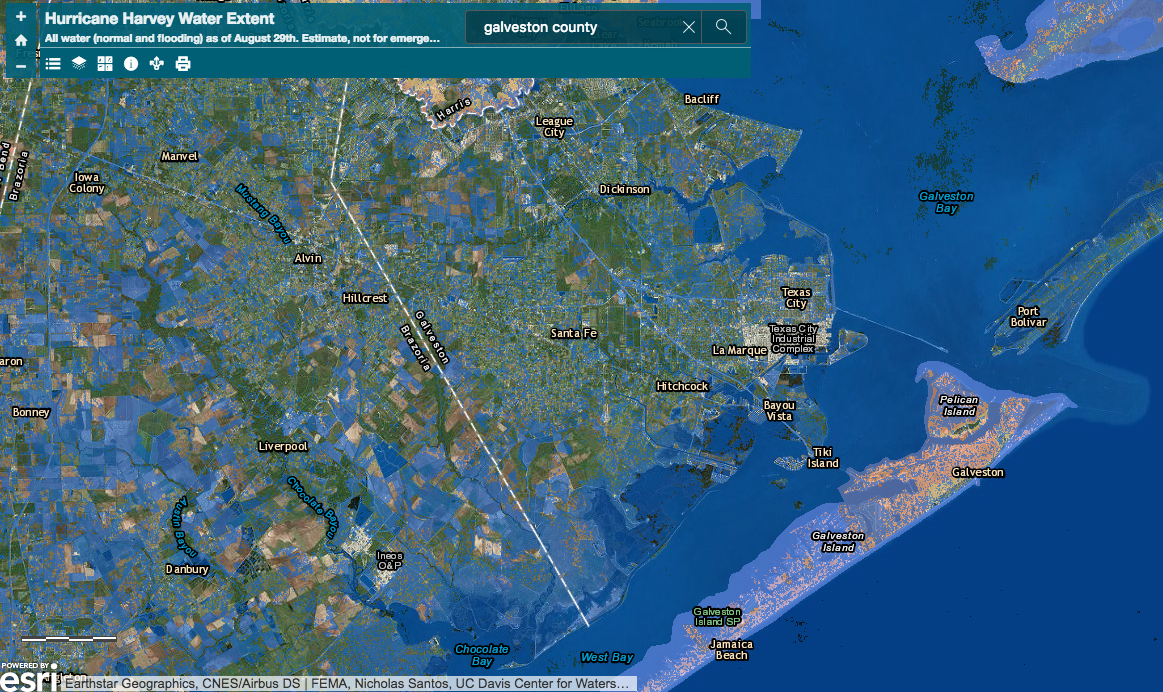 Flooding in Galveston during Hurricane Harvey. Source: UC Davis Center for Watershed Sciences Hurricane Harvey Water Extent Geographic. Human consequences:Galveston became a major U.S. commercial center and one of the largest ports in America during the 19th century. Whenever a major hurricane hits the county, its lack of a sustainable drainage system leaves many of its streets inundated with water for weeks. Without adequate flood safety measures, today 320,000 people are forced to evacuate from their homes at the approach of a hurricane. When these people are displaced and Galveston’s port is flooded, millions of dollars in goods from the commercial port are lost. Thousands of businesses around the United States that receive imported materials through this port are also impacted. Because Galveston County has long had a major commercial port, it has a great deal of infrastructure that is vulnerable to hurricanes. In 1900, it endured the deadliest natural disaster in American history, when the 15-foot storm surge of the Galveston Hurricane killed up to 12,000 people. In 1970, Hurricane Celia, a Category 4 storm, came ashore near Galveston and inflicted nearly $6 billion of damage in 2017 USD. Then, in 2017, Hurricane Harvey inflicted $23 billion worth of property damage in Harris and Galveston counties alone. Galveston County is extremely vulnerable to intense hurricanes, increasing local temperatures, and rising sea levels. As hurricanes strengthen and sea levels rise, the county may be hard pressed to survive the twenty-first century. Further reading:Article author: Kiera McCrane, Georgetown University
Article editor: Dr. Dagomar Degroot, Georgetown University 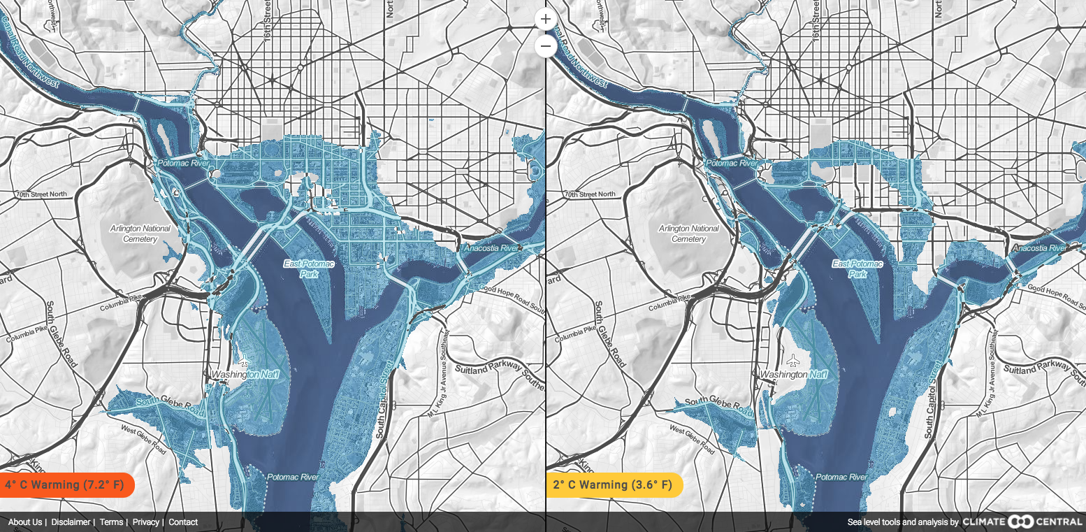 Projected sea level increases in 200-2000 years under different emissions scenarios. Climate changes and the local environment:The Paris Agreement on Climate aims to limit the increase in Earth's average temperature to 2° C, relative to pre-industrial levels. That will require dramatic cuts to human-caused greenhouse gas emissions, and in all likelihood new technology to draw carbon dioxide out of the atmosphere. Even if successful, however, these steps will still leave us with enough warming to greatly raise sea levels around the world. There are two reasons for this: first, warm liquids take up more volume than cold liquids, and second, water will flood into the oceans from ice caps on Greenland, West Antarctica, and other polar regions. Low-lying coastal regions, including much of Washington, DC, will eventually be flooded unless they are defended with extensive dikes and levees. If global temperatures rise by 4° C relative to pre-industrial averages - which they would if current long-term trends continue - then much of Washington, DC would ultimately be well below sea level. Climate projections based on continuing high greenhouse gas emissions - known as "high emissions scenarios" - predict that average water levels around Washington, DC would reach 3 feet above present levels by 2110. The city will be particularly vulnerable to flooding because it will be periodically threatened by hurricanes that could have higher sustained winds and higher storm surges than they do today. Under high emissions scenarios, there is a near certain chance by the end of the 21st century that the city will endure flooding more than 10 feet above the current high tide line. Climate projections based on continuing high greenhouse gas emissions estimate that the mean daily maximum temperature of Washington, DC will rise from roughly 20°C (68°F) to nearly 26°C (78°F) by 2100. Days with extreme heat (above 35°C, or 95°F) would increase by a factor of 9, from roughly 10 today to approximately 90 in 2100. Even if countries adhere to the Paris Agreement and sharply reduce their emissions, extreme heat days will probably still rise by a factor of 3, to roughly 30, by 2100. Precipitation patterns are unlikely to change as dramatically. 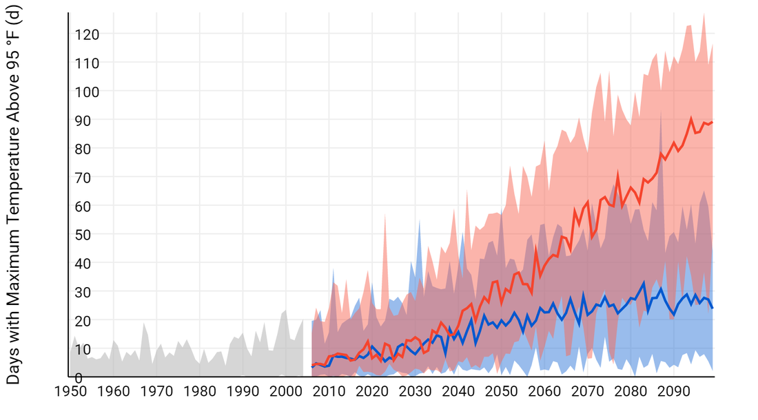 Extreme heat days, past, present, and future under high (red) and low (blue) emissions scenarios. Source: NOAA Climate Explorer. How we know:These projections primarily rely on two tools that are freely accessible online: the National Oceanic and Atmospheric Administration (NOAA) Climate Explorer app, and the Climate Central Surging Seas, Mapping Choices app. The Climate Explorer tool uses weather information recorded by meteorological instruments at weather stations to reconstruct past climate changes. It uses supercomputer simulations of future climate changes under both high and low emissions scenarios. The Surging Seas tool combines historic flood statistics and local sea level trends with global scenarios of sea level increases, which were compiled in the 2014 U.S. National Climate Assessment. Human consequences:Nearly 5,000 people live in nearly 2,000 homes on roughly 2,500 acres of land in parts of Washington that are currently under 10 feet above the high tide line. That territory is home to property worth $9 billion, and it includes 26 EPA-listed sites (including hazardous waste dumps and sewage sites). Under high emissions scenarios, all will be flooded by the year 2100. Even under low emissions scenarios, all will be permanently underwater, although that could take hundreds of years. Much of Washington, DC will eventually need to be evacuated or else protected by extensive and very expensive defenses against the sea, if these prove to be feasible. Under high emissions scenarios, extreme heat will severely tax transportation and electrical infrastructure in Washington, DC. Higher temperatures could increase the presence and transmission rate of disease, especially those that spread through mosquito vectors, such as Zika and malaria. Extreme heat days could well lead to increased mortality among the poor, sick, and elderly. The local human consequences of rising sea levels and temperatures will depend greatly on technological and social developments that are hard to foresee. Nevertheless, climate change should impact Washington, DC with particular force. Further reading:
Article author: Dr. Dagomar Degroot, Georgetown University
|
 RSS Feed